Architectural Description:
Style: Italianate/Queen Anne
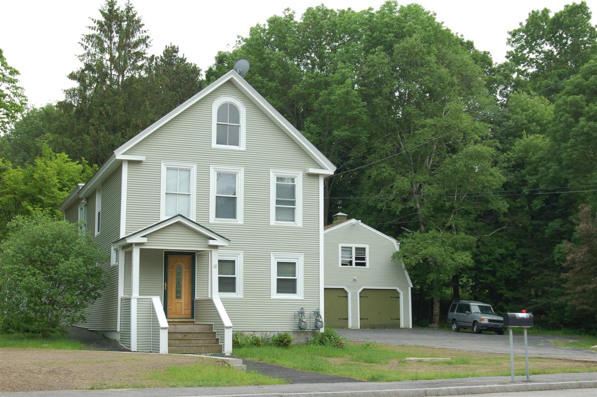
Architectural significance: Two-and-a-half-story residence with its gable end towards the street and a two-story bay window on the east side. Most of the windows display the original 2/2 sash. The most distinguishing detail of the house is the round-headed Italianate attic window in the gable end facing the street. According to the present owners, they believe that a single-story kitchen had been added to the rear elevation by about 1900, later raised to its present two-story height.
A large three-story barn also stood on the property, removed about 1977 to make way for the present garage.
Historical Narrative:
Historical significance: Although not identified by the 1906 map of Andover, this house appears to have been constructed considerably earlier, substantiated by deed research done by the Baileys. The original owner is not known.
By 1915, the property had been acquired by Lizzie (Stevens) Bailey, who assembled a 44-parcel subdivision known as "Stevens Park" between River Road and Webster Street. The engineer who laid out the development was John Franklin of Lawrence, later responsible for laying out Shawsheen Village. The development never worked out, possibly because of the small lot size (more appropriate to city lots than rural subdivisions of the period). The two principle streets, Bailey and Stevens street, proposed to bisect the subdivision, remain "paper streets" to this day.
12 River Road, like many houses close to Lawrence, was occupied for much of its later history by Lawrence mill operatives. Lizzie Bailey sold the property in 1915 to Henry P. Lannan (c. 1859 - 1929), a Lawrence butcher. The large three-story barn which stood adjacent was said to have been used for butchering, with a large walk-in freezer. Within three weeks he had moved to Lawrence and sold the property to Louis and Hortense Deconningh. Deconningh and his daughter Zoe Madeline were both weavers, presumably working in one of the mills in Lawrence. Another mill "operative" , Matthew (or Motejii) Tatulis bought the property in 1932. By 1938, John Stasukiewicz, a 42-year old mill operative, was living here with his wife Mary. Today the property is owned by Lizzie Bailey's grandson and his wife.
Bibliography/References:
Essex Northern Registry Deeds, Lawrence, MA
Interview with Frank and Eileen Bailey (24 Oct 1987)
Franklin, John, C.E., "Plan of Stevens Park", (1910), Plan #135 in the Essex County Registry of Deeds.
Andover Street Directories. Andover Historical Society
Owners;
Lizzie F. Bailey -
Henry P. Lannon, wife Ellen - Oct. 7, 1915 - b. 358 p. 550
Hortense Deconningh, wife of Louis - Oct. 7, 1915 - b. 358 p. 550
Motejis & Christina Talulis - May 28, 1923 - b. 479 p. 541
Wiadyslaw & Katherine Fecko - July 19, 1932 - b. 565 p. 433
Annette A. Frechellte - Feb. 17, 1934 - b. 576 p. 99 - deed transfer
Wiadyslaw [Edward] Fecko - Feb. 17, 1934 - b. 576 p. 100
Wiadyslaw [Edward] Fecko estate, Catheirne R. Feco, Adm. - Feb. 15, 1935 - Probate
Catherine R. Feco - Mar. 25, 1935 - b. 588 p. 507
Mary Stasiukewicz, wife of John - May 1, 1935 - b. 589 p. 122
Francis W. & Eileen K. Bailey - July 27, 1953 - b. 778 p. 411
Christine G. Popadak - Mar. 24, 1986 - b. 2154 p. 79 - deed transfer
Francis W. & Eileen K. BaileyMar. 24, 1986 - b. 2154 p. 80
Benigno A. & Carmen A. Espaillat - Nov. 30, 1992 - b. 3605 p. 128
Inventory Data:
| Street | River Rd |
| Place | North District - West Parish - West Andover |
| Historic District | Not Applicable |
| Present Use | Residence |
| Original Use | Residence |
| Construction Date | 1880s |
| Source | ECRDS, ENRDL, style-njs |
| Architectural Style | Other |
| Foundation | stone |
| Wall/Trim | asbestos shingles/vinyl clapboard |
| Roof | asphalt - gable |
| Outbuildings / Secondary Structures | Garage (1977) Attached shed (1977) |
| Major Alterations | Rear kitchen (c. 1900), vinyl siding, replacement windows and front door |
| Condition | good |
| Acreage | 1.04 acres; Acreage: about 2 acres |
| Setting | residential |
| Map and parcel | 127-16 |
| Recorded by | Peter H. Stott, Org.:BU OPA, James Batchelder |
| Organization | Andover Historical Society, Andover Preservation Commission |
| Date entered | 25 Oct 1987, 1/21/2016 |

