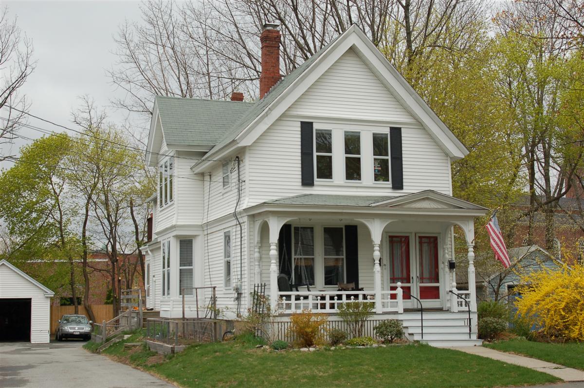
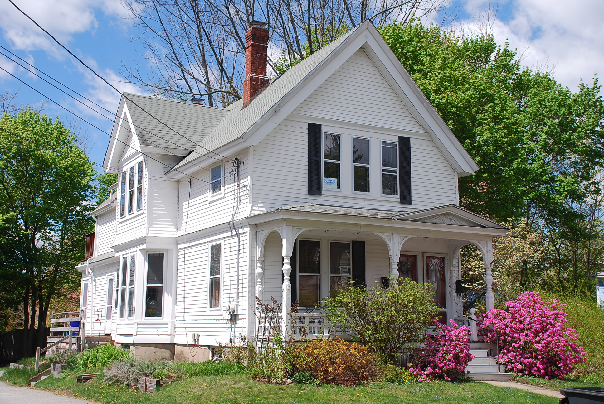
Architectural Description:
Eastlake style detail in woodwork; scalloped, decorative, and detailed carvings.
Historical Narrative:
Themes: Architectural, Community development
Florence Street was constructed in 1885. The south end portion (Park St.) of two acres and 28,045 sq. ft. was owned by Hannah W. Foster, wife of Joseph W. Foster. Hannah sold the parcel to William Wood, a carpenter for $1900 on March 13, 1883. Wood built his home at 66 Park St. and house lots extended on both sides up to #21 and #24. The north end portion (Elm St.) on the east side was the former Moses Abbot Jr. homestead at #49 Elm St. Owned by his son George T. Abbott, also a Housewright, who was partners with William S. Jenkins in the firm Abbott & Jenkins. The Abbot parcel extended to #20.
The west side of Florence St. to #17 was formerly owned by the Henry Burtt estate formerly at #35-#37 Elm St.
Oct. 2, 1885 Andover Advertiser - pg. 2 col. 9, “The new way between Park and Elm has been completed by Nathan F. Abbott, the contractor, and accepted by the Selectman. Several names have been suggested……”
House lots were then created and sold to a variety of residents. William Wood sold the parcel of land on the west side of Florence St. (containing lots #33 -21) to Charles O. Stevens, wife Abbie on Mar. 22, 1886. Stevens took a loan from the Andover Savings bank on Mar. 19, 1887 but was later declared insolvent on May 8, 1887. The bank then sold the mortgage to Andover dentist Charles H. Gilbert on July 11, 1887 for $400. Gilbert then sold off the corner lot at Park & Florence Streets to John Cornell on Aug. 13, 1887.
The bank then released a partial deed to Charles H. Gilbert on Oct. 11, 1887 lot #27 which he then sold to Erastus Gile. Charles Gilbert then sold the remaining parcel to Abby R. Handy & Elizabeth R. Handy on July 9, 1888. The deed contained two parcels, one on High St. and this lot on Florence, which included lot 21 & 25 The next year Abby & Elizabeth Handy sold the Florence St lot fro $2500 to Erastus Gile on Aug. 17,1889. Gile now owned the three adjoining parcels. #27 and #25 & #21-#23.
Erastus Gile was born on Jan. 29, 1818 in Lee, NH, son of George & Clarissa (Durgin) Gile. Erastus was a stone and brick mason. Erastus married in Andover on Aug. 27, 1842 to Amanda Georgette Manning of Tewksbury, b. 1814, dau. of Benjamin & Sarah (Simmonds) Manning. They had six children: Amanda Georgette b. Sept. 18,1843, Mary E. b. Mar. 1845, Sarah M. b. Oct. 1846, Clara b. 1849 - 1851, Edward E. b. 1851 and Sylvia Annie b. Dec. 1854. Gile rented half the house at 53 Red Spring Rd. prior to building his new double house at 161-163 North Main St. in 1850. The Giles lived at #161. Erastus Gile was hired by the Town of Andover as one of the masons for the Old Town Hall on Main St. Gile did several brick buildings in town.
Erastus Gile died on April 23, 1893 at age 75 years. His estate went to his wife Amanda and children named as the Executors of his estate. Widow Amanda died at age 81 on March 26, 1895. The four daughters inherit the property. Daughter Georgette Amanda was a seamstress, Mary & Sarah became teachers, and son Edward followed his father's occupation as a mason. The Giles also continued ownership of the North Main St. property until Apr. 29, 1930.
The 1900 through 1920 Census have the daughters living at 11 Florence St. which we believe to be #21. The sisters sell #27 Florence St. to F. Howard Wilkes on Sept. 14, 1920. The 1906 map of Florence St. does not show the house at #25 and it is not clear when it was built or if it was moved here from Park St. The Gile family owned the property until 1934. The 1920 Andover Valuation Schedule lists the Gile daughter's Georgette A., Mary E. and S. Annie: 11 Florence St. house $2000., barn and shed $400. land 21,051 sq. ft. $1600. then 15 Florence St. House $1800, Barn $200, 1/4 acre land $1100. and 1/2 house at 161 No. Main St. $1300., and 1/8 acre $500.
Bibliography/References:
Essex County Registry Deeds, Salem, MA
Essex Northern Registry Deeds, Lawrence, MA
Map plan #12526 - May 1993 - Reciprocal driveway Lot B
Owners;
Hannah W. Foster, wife of Joseph W. - 1883 - 2 acres + land
William Wood - Mar. 13, 1883 - b. 71 p. 252 - 2 acres + land
Charles O. Stevens, wife Abbie - Mar. 22, 1886 - b. 85 p. 186 - 4 lots
Charles O Stevens, mtg. Andover Savings Bank - Mar. 19, 1887 - b. 90 p. 1
Charles O Stevens insolvency - May 8, 1887
Charles H. Gilbert - July 11, 1887 - b. 91 p. 291 - assignee - $400.
Charles H. Gilbert - Aug. 13, 1887 - b. 92 p. 148 - lots #21- #44
Abby R. Handy & Elizabeth R. Handy - July 9, 1888 - b. 96 p. 86 - parcel 2 lots #25 & 21-23
Erastus Gile - Aug. 17,1889 - b. 102 p. 153 - $2500 - lots #25 & 21-23
Erastus Gile estate, d. Apr. 23, 1893 - heirs; Amanda G. & children - 1893 - Probate
Amanda Gile estate, d. Mar. 26, 1895 - heirs; Georgette A., Mary E., Sarah M. Silvia Annie Gile
Sarah Gile estate, 1920 heirs; Georgette A., Mary E., S. Annie Gile
Georgette A. Gile estate, 1934, Fred E. Cheever, Extr. - Probate
Katherine M, Mary J, Helen C. Anne M & Eliz. R. Sweeney - Mar. 31, 1934 - b. 577 p. 317
Elizabeth R. Sweeney estate, Katherine M. Sweeney Extrix - Nov.16, 1965 - Probate - b. 1049 p. 25
Frances "Jill" L. (Sweeney) Walsh - Apr. 29, 1986 - b. 2183 p. 338
Frances Lee & William J. Walsh - July 18, 1986 - b. 2251 p. 29
Walsh Investment Realty Trust - Apr. 30, 2010 - b. 12019 p. 225
Inventory Data:
| Street | Florence St |
| Place | Andover Center |
| Historic District | Andover Historic Building Survey |
| Historic Name | Gile Sisters House |
| Present Use | residence - two family |
| Original Use | residence |
| Construction Date | 1887 |
| Source | ECRDS, ENRDL, style-njs,Andover Assessor's Office |
| Architectural Style | Queen Anne |
| Foundation | stone/granite/brick |
| Wall/Trim | cedar shingles/clapboards/vinyl clad |
| Roof | asphalt - gable |
| Outbuildings / Secondary Structures | garage |
| Major Alterations | vinyl siding clads most of the original shingle details of the gables and banding. Replacement windows. |
| Condition | excellent |
| Acreage | 0.152 acre; 12,420 sq. ft.; approx. frontage 85' |
| Setting | residential/business |
| Map and parcel | 39-12A |
| Recorded by | Stack/Mofford, James S. Batchelder |
| Organization | Andover Preservation Commission |
| Date entered | 1975-1977, 4/7/2017 |


