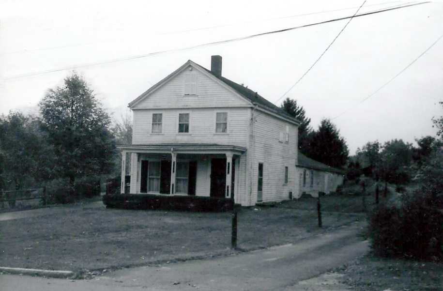
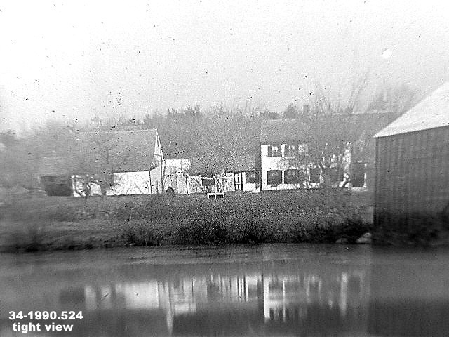
Architectural Description:
NRDIS, Greek Revival -picturesque
Gable end to street, connection ell and sheds
Porch posts like those of Elm St., High St., and Salem St. houses
Historical Narrative:
At the entrance of Hunters Ridge on Martingale Lane once stood a Greek Revival farmhouse numbered 60 Poor St. The property was sold by Nathan[iel] Bailey Jr. to Elijah Hussey for $420 on March 16, 1846 and remained with the Hussey family until 1882. The deed included 3 1/2 acres, with flowage rights for Hussey and a right of way for Bailey to access his other property from Poor St.
Wyman D. Hussey inherited the property and sold to Joseph W. Smith on July 7, 1882. Joseph Warren Smith was the son of John Smith, founder of the Smith & Dove Co. Joseph deeded the property to his wife Fannie S. Smith on Feb. 7, 1889. Joseph & Fanny Smith lived in the Smith Mansion on North Main Street, the former Shawsheen Manor razed in 1988.
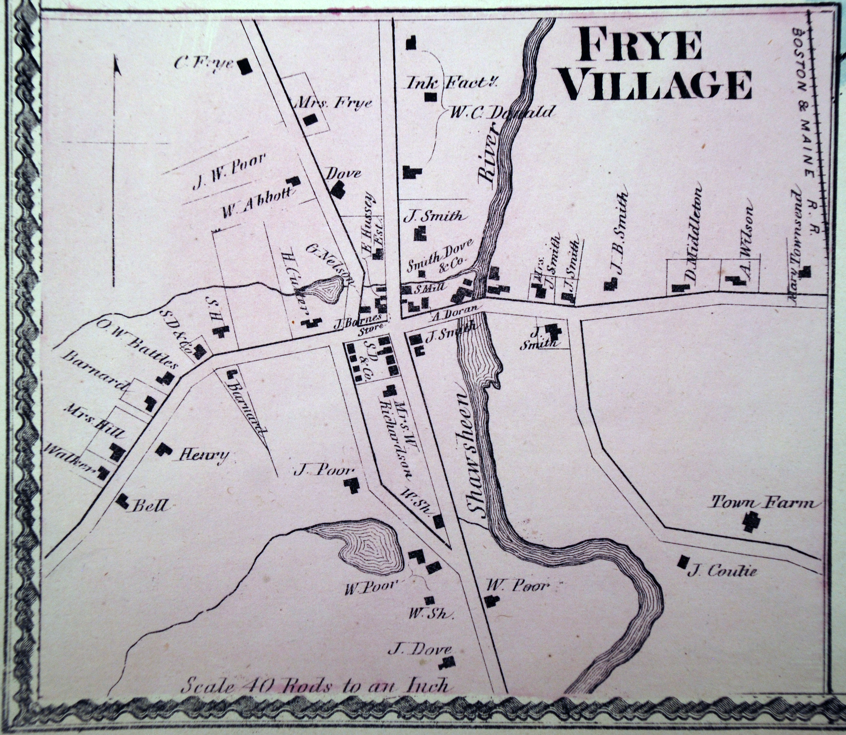
This home was most likely income property for the Hussey and Smith families, as Charles Henry Bell and family are listed here in 1870 census. The 1872 map of Frye Village marks a W. Abbott on this home. Bell would later purchase the property through his son John W. Bell who bought on May 17, 1889, then deeded to Charles H. Bell on June 24, 1889.
Charles Henry Bell was born on June15, 1832 in Goffstown, NH son of Peter & Mary (Bodwell) Bell. His father was from Goffstown and mother Mary was born in Methuen, MA. Charles H., known as Henry, was a Cordwainer, or shoemaker. He married on May 6, 1955 in Andover to Christina R. Walker b. Aug. 8, 1835 in Scotland, daughter of McNeil & Barbara (Murray) Walker. Walker lived nearby on Lowell Street. C. Henry Bell enlisted during the Civil War served with Co. H. 1st Mass Heavy Artillery.
Children; John W. b. 1855, Laura B. 1857 - d. 1863, Phoebe b. 1860 - d. 1863, Clara May b. Aug. 19, 1865 - d. 1944, Charles H. Jr. b. 1871, and Stewart Sargent b. July 15, 1874 - d. 1928.
C. Henry deeded the property to his wife Christina on July 2, 1894. His health may have been failing as he died on June 4, 1897. Christine remained in the home then sold to Anthony & Jane McCloud on Aug. 12, 1902. McCloud owned for three years then selling to Henry Todd on May 27, 1905.
Henry Todd was born in Belfast, Northern Ireland on June 21, 1876 son of William & Elizabeth (Shaw) Todd. He immigrated to the US with his family in 1885 (1881 1910 census). He was living in Lawrence, MA at the time of his wedding on June 18, 1902. Henry married Lucetta Hilton b. 1876 in Saugus, MA, dau. of Henry & Sarah Ann (Batty) Hilton. Henry was a Folder and Lucetta a Weaver in the mills in Lawrence. The home and property would have a Todd connection for 78 years.
Henry joined the St. Matthew's Mason Lodge in Andover in 1912. His occupation is listed as Bleacher at the time. In 1917 he is a salesman for Lawrence Gas Co. and later a clerk. Henry would become a janitor at the new Shawsheen School just up the hill from their home.
Henry and Lucetta had two children, Ruth O. b. 1908 and Kenneth b. 1913. With the death of his wife, Henry then held the property jointly with his daughter Ruth Southworth on Mar. 23, 1962. Ruth Todd was married to Palmer Southworth. Henry died on October 14, 1964 and Ruth inherited the home. The deed was place in both Palmer & Ruth Southworth names on May 18, 1967.
Ruth Southworth estate was probated on Sept. 10, 1980 and the property was then sold to James M. & Maureen Barenboin on Jan. 14, 1983. The house was purchased as rental income property. On Feb. 10, 1985 an electrical fire in the attic destroyed much of the interior of the home. William & Martina Miller were occupants at the time of the fire. The house was razed shortly after and the 11 acre property was sold to Hunters Ridge, McNeil Condominium Corp. on Sept. 15, 2005. Martingale Lane was laid out in the location of the former home.
Andover Condominium Associates Limited then developed the condo units of Hunter Ridge.
66 Poor Street was sub-divided into three separate condo lots and one unit is now assigned the 60 Poor Street, but was once the front yard of 66 Poor and not part of the the Bell House lot.
Bibliography/References:
Essex County Registry Deeds, Salem, MA
Essex Northern Registry Deeds, Lawrence, MA
Themes: Architectural and Community Development
Owners;
Nathan[iel] Bailey Jr., wife Pamelia F.
Elijah Hussey - March 16, 1846 - b. 382 leaf 190 - # 1/2 acres $420
Wyman D. Hussey - heir by Will
Joseph W. Smith - July 7, 1882 - b. 68 p. 557
Fannie S. Smith, wife of Joseph W. Smith - Feb. 7, 1889 - b. 101 p. 123
John W. Bell - May 17, 1889 - b. 101 p. 124
Charles H. Bell - June 24, 1889 - June 24, 1889 - p. 101 p. 125
John W. Bell - July 7, 1894 - b. 134 p. 357
Christina R. Bell - July 2, 1894 - b. 134 p. 358
Anthony & Jane McCloud - Aug. 12, 1902 - b. 196 p. 546
Henry Todd - May 27, 1905 - b. 220 p. 576
Max Goldstein - May 15, 1933 - b. 570 p. 343
Henry & Lucetta Todd - May 15, 1933 - b. 570 p. 344
Henry Todd & Ruth Southworth - Mar. 23, 1962 - b. 955 p. 4
Palmer & Ruth Southworth - May 18, 1967 - b. 1082 p. 106
Ruth Southworth estate, Maurice Rappaport, Extrix,- Sept. 10, 1980 - b. 1453 p. 295
James M. & Maureen Barenboin - Jan. 14, 1983 - b. 1638 p. 88
Hunters Ridge, McNeil Condominium Corp. - Sept. 15, 2005 - b. 9766 p. 331
Andover Condominium Associates Limited - Sept. 29, 2006 - b. 2314 p. 220
Also see deed Charles H. Bell - Dec. 9, 1879 - b. 58 p. 126 - 8 1/2 acres & building
Moses E. Abbott, wife Susan - b. 41 leaf 144 - Salem deed from Mary P. Abbott
Inventory Data:
| Street | Poor St |
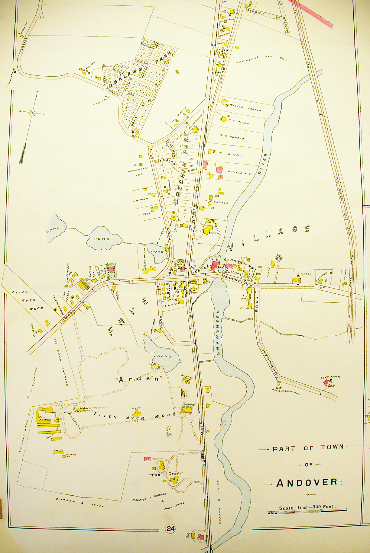
| Place | Shawsheen Village - Frye Village |
| Historic District | Shawsheen Village NRH District |
| Historic Name | Hussey - Bell House |
| Present Use | residence - condo |
| Original Use | residence |
| Construction Date | 1840's |
| Source | ERDS, ENRDL, AHS file, njs, style |
| Architectural Style | Greek Revival |
| Foundation | stone & granite |
| Wall/Trim | clapboards/wood |
| Roof | asphalt - gable |
| Outbuildings / Secondary Structures | small barn - razed |
| Major Alterations | Condo development in 1999 Fire destroyed the home on Feb. 10, 1985 |
| Condition | razed 1985 after fire |
| Demolished? | Yes |
| Demolition Details | destroyed by fire Feb. 10, 1985 |
| Acreage | 10.96 acres, 145' frontage |
| Setting | residential |
| Map and parcel | 52-94 |
| MHC Number | ANV.439 |
| Recorded by | Stack/Mofford, James Batchelder |
| Organization | Andover Preservation Commission |
| Date entered | 1975-77, 06/03/2015 |


