Historical Narrative:
Johnson Acres was created in 1935 by Fred E. Cheever on the former George J. Thornton and Rev Francis H. Johnson estates. The mansion and out buildings were razed and the 35-acre property was sub-divided. The development includes Johnson Road, the former driveway to the house, Cheever Circle, Cedar Rd., Coolidge, Cabot, and Shipman Roads.
The history of the property includes Hobart Clark, who lived at 134 Elm St, sold two parcels of his land in 1846, of about 10 acres, to Mortimer C. Ferris, a Boston merchant. Ferries later sold the property to George J. Thornton on July 1, 1851. The 1850 Valuation Schedule lists Geo. J. Thorton; dwelling house $550, 9 3/4 acres land $975 = $1525. Thornton paid $3100 for the land and took a 10-year mortgage loan from Ferris of $3000. George Thornton was a gardener and had an extensive garden nursery and home on the property. Thornton also borrowed $500 from Betsey Dawson, $150 from Samuel G. Valpey and an additional $1000 from Ferris.
Ferris sold his mortgage loan to George H. French, a Trader, on July 9, 1853. Thornton would later sell to George H. French on on Mar. 25, 1856. French then sold the property to bookbinder Charles B Clark, wife Lydia of Concord, MA on Mar. 25, 1856. Clark paid $3000 for dwelling house and 10 acres of land.
Andover Advertiser - April 25, 1857 – Lot of land known as the “Thornton Place” owned by Charles B. Clark, 10 acres – on which is a small tenement, in good order, one half mile from the depot on the road to North Andover, land elevated giving a fine view of the village of Andover.
Clark took a mortgage loan with the Trustees of Phillips Academy for $1200 in 1856 but was declared insolvent on Feb. 2, 1857. His estate was assigned to Moses D. Phillips of Boston and sold on June 12, 1857 to George L. Abbott & Moses Clement, both Andover house-wrights and business partners in the firm Abbott & Clement. They paid $1500 for the property and assumed the P.A. mortgage. It is not known if Abbott & Clement enhanced the property at that time but they did hold the parcel for two years. They then sold to Samuel Raymond on Aug. 9, 1859 for $525 plus assuming the outstanding mortgage. The 1860 Valuation; Samuel Raymond, house and 9 3/4 acres = $1300, Personal estate; money $3000, stocks $498.
Samuel Raymond, wife Emily F. M. owned for eight years then selling to Rev. Francis H. Johnson of Boston on Feb. 11, 1867.
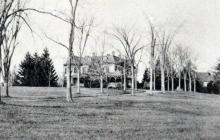
Johnson paid $10,000. for the house and 10 acres. The 1870 Valuation lists Johnson; House $4000, Barn & shed $800, 22 1/2 acres $3200 = $8000. Farm stock $360, money $440 - $800. Johnson added three more parcels to his property which had, at that time, a commanding view of Andover from his hilltop home. The total estate grew to 35 acres. The house is believed to have been sited approximately between Coolidge and Cabot Roads.
Andover Advertiser - Sept. 26, 1873 - Rev. F. H. Johnson has made an addition 18 x 46 to the west side of his hitherto beautiful residence. The front is now of octagon form, and the piazzas twelve feet wide adds greatly to the beauty of the mansion.
Rev. Francis Howe Johnson was born Jan. 15, 1835 in Boston, MA, son of Samuel & Charlotte Abigail (Howe) Johnson. Francis married on June 6, 1867 to Mary "Marcy" Alexander Dove b. Sept. 13, 1840 in Andover, daughter of John and Helen “Ellen” (McLaggan) Dove. Marcy's father, John Dove, was the business partner of John & Peter Smith in the Smith & Dove Manufacturing Co. in Andover. Francis and Marcy had two sons: Grahame Dove b. Oct. 8, 1870 in Warwickshire, England and Reginald Mansfield b. Feb. 5, 1876 in Andover, MA. Mary died at age 52 of peritonitis. She is interred at Phillips Academy Cemetery. Feb. 10, 1893 AT Obit. of Mrs. Mary A. Johnson, wife of Rev. Francis Johnson, dau. of John & Helen Dove. Burial at Chapel Cemetery –
Rev. Johnson would remarry on Oct. 24, 1894 to Mary Beach, b. Jan. 17, 1844 in Fulton, CT, daughter of Hunn Carriington Beach & Mary Charlotte (de Koven) Beach.
The 1900 Census gives insight to the extent of the family house. Francis Johnson - Clergyman, Mary B. and the following servants: Annette Bennet 28, b. Ire. Lady's maid, Maude Young 25 b. Maine Parlor maid, Margaret Galvin 30, b. Ire. Waitress, Mary Truland 30, b. Ire. Cook, Ellen Collins 42 b. Ire. Laundress, Timothy O'Sullivan 42 b. Ire. Butler, his wife Elizabeth O'Sullivan 35 b. Ire. House servant and thier four children, Bartholomew 10, b. NY, Elizabeth A. 9 b. NY, Margaret 7 b. NY and Timothy J. 3 b. NY. It is interesting to note there is no carriage man listed. The 1920 Andover Valuation schedule lists: House $15000.,Barn & shed $1000., Carriage house and Henhouse $700. 35 acres land $14000. Johnson also owned a house at 35 Washington Ave. $2000. 15360 sq. ft. lot $800. for a total assessment of $33500. This residence remained in the Johnson family until 1934.
Francis H. Johnson died on October 27, 1920 in Washington DC. He is interred at Phillips Academy Cemetery. His son Grahame died on Nov. 11, 1922 in Philadelphia and Reginald M. the following year on Feb. 11, 1923. Both sons had married and Grahame had one surviving daughter, and Reginald two daughters and two sons. Francis and Mary Beach had no children. Mary Beach died on Nov. 12, 1931. The Johnson estate was sold to Fred E. Cheever, an Andover native and Real Estate agent.
Fred E. Cheever created "Johnson Acres" housing development on the former Johnson estate. The mansion house was razed and the main driveway became Johnson Rd. with Cheever Circle, Cedar Rd. Coolidge and Cabot Roads. Cheever embraced the Colonial Revival style and many of the homes built reflect that style. His lots were sold with certain deed restrictions including each home had to worth at least $8000, a single family residence, with setbacks, garage stipulations and no per-fabricated homes were allowed.
Bibliography/References:
Essex County Registry Deeds, Salem, MA
Essex Northern Registry Deeds, Lawrence, MA
Andover Advertiser - Sept. 26, 1873
Ancestry.com - Dove and Johnson family Genealogies
Andover Valuation Schedule 1920
Owners;
Hobart Clark - 1846
Mortimer C. Ferris - Aug. 13, 1846 - b. 370 leaf 276 - land
Mortimer C. Ferris - Dec. 12, 1846 - b. 376 leaf 103 - 1 a 129 sq. rds.
George J. Thornton - July 1, 1851 - b. 448 leaf 48 - $3100.
Thornton to Mortimer C. Ferris - July 1, 1851 - b. 448 leaf 49 - mtg. loan $3000. - 9 acres 129 rds.
Ferris to George H. French - July 9, 1853 - b. 480 leaf 226 - mtg. assigned $3000.
Thornton to Betsey Dawson - mtg. loan $500.
Thornton to Samuel G. Valpey - Dec. 6, 1852 - mtg. loan - $150
Thornton to Geo. H. French -Dec. 18, 1854 - b. 505 leaf 97 - mtg. loan $100
Thornton to Geo. H. French - Mar. 25, 1856 - b. 528 leaf 260 - deed
Charles B. Clark - Mar. 25, 1856 - b. 528 leaf 260 - $3000 - 10 acres w. dwelling
Charles B. Clark estate, Moses D. Phillips, assignee - Jan. 17, 1857 - insolvent
George L. Abbott & Moses Clement - "Abbott & Clement" - June 12, 1857 - b. 555 leaf 10
Samuel Raymond - Aug. 9, 1859 - b. 592 p. 137 - $525 with dwelling & mtg.
Francis H. Johnson - Feb. 11, 1867 - b. 718 leaf 282 - $10,000 - with dwelling
Francis H. Johnson estate, heir wife Mary B., son Reginald M. - d. Oct. 27, 1920 - Probate #137,778 - Essex Co.
Reginald M. Johnson estate, heir Mary B. Johnson - d. Feb. 11, 1923 - Probate #62996 - Norfolk Co.
Mary Beach Johnson estate, Francis J. O. Alsop, John Rice Trustees - d. Nov. 11, 1931 - Probate #78773 - Norfolk Co.
Fred E. Cheever - Oct. 15, 1934 - b. 582 p. 472
Fred E. Cheever - "Johnson Acres Estates" 1935 - 1937
Inventory Data:
| Street | Elm St |
| Place | Andover Center District |
| Historic Name | Thornton - Johnson Estate |
| Present Use | Johnson Acres Developement |
| Original Use | Residence |
| Construction Date | 1850 - 1851 |
| Source | ECRDS, ENRDL, style-njs |
| Architectural Style | Other |
| Foundation | stone, granite |
| Wall/Trim | clapboard/wood |
| Roof | hip/wood shingle |
| Outbuildings / Secondary Structures | Barn, shed, Carriage house |
| Major Alterations | 1873 additions, porches and turret add to existing house by Rev. Johnson |
| Condition | Razed |
| Demolished? | Yes |
| Demolition Details | Razed in 1935 for housing developemenr |
| Setting | Residential |
| Map and parcel | 20-144 |
| Recorded by | James S. Batchelder |
| Organization | Andover Preservation Commission |
| Date entered | June 7, 2016 |


