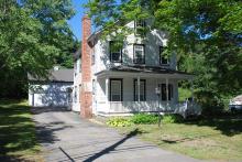
Architectural Description:
LHD
Style: Late Greek
Other features: gable roof; steam and auto burners for heating
Historical Narrative:
Themes: Architectural, Community development
This property was once owned by Alfred Kittredge, of North Andover, President of the Abbot Hat Company. Alfred sold this parcel of land to his company on May 16, 1864 for $200. The following year the property was sold to Hart, Taylor & Company of Boston, partners Thomas W. Hart, Frederick B. Taylor and Orin B. North. The gentlemen then sold this property along with three other parcels to the Whipple File & Steel Manufacturing Co. on Sept. 1, 1865. This was the fourth parcel listed in the deed.
The home was most likely built by the Whipple File Co. in 1865. The file company went bankrupt and the assignees. Edward Page, John Beals, Thomas J. Horner and Thornton K. Lothrop took control of the company holdings. They sold off the parcel with building to Stephen Blaney, wife Mary. Blaney would later sell to Catherine Carey on Aug. 9, 1892 for $2050. Blaney held the mortgage which he later assigned to Newton Jaquith. With Jaquith's death his estate, administered by Mary A. Jaquith took possession of the property on Sept. 30, 1918 and then sold at auction to Newton F. Frye of North Andover for $727.
Frye then sold the home to Flora White, wife of Arthur White on November 5, 1918. White owned for five years then selling to Edgar & Jennie Northam on Oct. 15, 1923. Maxwell "Max" & Lottie F. Lyons purchased the property on August 27, 1929. They would later sell off a portion of the property to Edward P. Hall allowing for the development of Hall Avenue between Andover St. and Clark Road.
George H. & Louise B. Manock were the next owners, purchasing on June 21, 1943. Manock owned for 25 years. George died on Feb. 12, 1962 and his widow Louise would later sell in Apr. 1968 to Alan & Ruth Henderson. The Henderson family were long term owners of 42 years.
Bibliography/References:
Essex County Registry Deeds, Salem, MA
Essex Northern Registry Deeds, Lawrence, MA
Map plan - #1081 - July 1936 - Edward P. Hall
Map plan #4832 - July 1963 - Louise B. Manock
Owners:
Alfred Kittredge - 1864
Abbot Hat Company - May 16, 1864 - b. 668 leaf 94 - $200.
Hart, Taylor & Co., Thomas W. Hart, Fred. B. Taylor, Orin B. North - June 8, 1865 - b. 684 leaf 274
Whipple File & Steel Manuf. Co. - Sept. 1, 1865 - b. 689 leaf 155 (lf. 156 parcel 4)
Edward Page, John Beals, Thomas J. Horner, Thornton K. Lothrup - Assignees - 2nd parcel
Stephen Blaney - b. 6 p. 236 - 239
Catherine Carey - Aug. 9, 1892 - b. 121 p. 386
Stephen Blaney - Sept. 3, 1892 - b. 120 p. 493 - mtg. deed
Newton Jaquith estate, Mary A. Jaquith Adm. - Sept. 30, 1918 - b. 391 p. 156 - mtg deed
Newton F. Frye - Sept. 30, 1918 - b. 391 p. 157 - mtg. sale
Flora White, wife of Arthur - Nov. 5, 1918 - b. 392 p. 356
Edgar & Jennie Northam - Oct. 15, 1923 - b. 488 p. 73
Maxwell "Max" T. & Lottie F. Lyons - Aug. 27, 1929 - b. 548 p. 71
George H. & Louise B. Manock - June 21, 1943 - b. 659 p. 243
George H. Manock estate, heir Louise B. Manock - Feb. 12, 1962
Alan M. & Ruth E. Henderson - Apr. 30, 1968 - b. 1105 p. 24
Sheila Lane, Russell Henderson, Cheryl L. Ott - Dec. 16, 2004 - b. 9260 p. 65
Alan M. & Ruth E. Henderson - Aug. 21, 2008 - b. 11750 p. 321
James L. & Lauren M. Christenson - Mar. 25, 2010 - b. 11983 p. 78
Hall to Lyons, Lyons to Hall - Dec. 28, 1936 - b. 604 p. 268-269 - Hall Ave land.
Inventory Data:
| Street | Andover St |
| Place | Ballardvale |
| Historic District | Ballardvale Local Historic District |
| Historic District | Ballardvale National Register District |
| Present Use | Residence - Duplex |
| Original Use | residence |
| Construction Date | 1865 |
| Source | ECRDS, ENRDL, style-njs |
| Architectural Style | Greek Revival |
| Foundation | stone/granite/brick |
| Wall/Trim | clapboards/wood |
| Roof | asphalt - gable |
| Outbuildings / Secondary Structures | large barn |
| Major Alterations | pool (1977) Removal of ell, new chimney & fireplace |
| Condition | excellent |
| Acreage | 0.496 acre; lot size: 21,600 sq. ft.; approx. frontage: 56' |
| Setting | residential |
| Map and parcel | 115-9 |
| MHC Number | ANV.19 |
| Recorded by | Stack/Mofford, James S. Batchelder |
| Organization | Andover Preservation Commission |
| Date entered | 1975 - 1977, 9/14/2016 |


