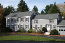
Architectural Description:
Federal Period style
Historical Narrative:
The deeds lead to William Wardwell's estate sold by his son Peter Wardwell, wife Betsy to James Holt Jr. on Dec. 21, 1793. Holt paid 359 pounds, 15 shillings for the four parcels of land. The first lot of 20 acres includes the homestead. The estate "reserved the privilege in the dwelling house given to my sister in my father's last will and testament."
James Holt Jr. wife Dorothy and two daughters Dorothy Riggs, wife of Asa, and Hannah Wiggins, wife of Benjamin, inherit James' estate, each with a 1/3 share. The daughters sell their share to Ebenezer Perry on June 16, 1808 for $350. Widow Dorothy Holt given use as Dower by probate court later sells her share for $250 to Perry on June 2, 1810. Ebenezer & Elizabeth Perry own for seven years. Perry sold the property to Convers Francis of Medford, MA on May 1, 1815 which contained four parcels of land. Lot 1 was 6 acres 90 poles in Pine Swamp. Lot 2 - 23 acres 20 pole in Rail Swamp pasture. Lot 3 was the homestead lot containing the dwelling house and buildings on 16 acres 80 poles and the 4th lot of 17 1/2 acres. Francis sold the property to David Holt Jr. on May 10, 1816 for $2000.
David Holt Jr. and Isaac Osgood Jr., both of Andover, Traders. built a Federal Brick Block in 1814 on Elm Square at 1 Main St. Holt & Osgood paid $400 for the land on May 3, 1814. Located on the Westerly side of the Essex Turnpike and on the Southeasterly side of the street leading from Foster’s Tavern to the meeting house. It is unknown at this time how long the partnership continued or what retail business the men established in their new building. The building housed three stores on the street level and offices and a meeting hall on the top floors.
At some point the partnership was dissolved as all of David Holt’s estate was placed into a trust. Hobart Clark and later John Flint were appointed trustees and guardians by order of the court in Newburyport on June 13, 1829 for David Holt, Yeoman, who "was given to excessive drinking and idleness". Some of his property had to be sold off in 1829 and 1830 to raise $4050 to pay Holt’s debts. The trust notes two brothers, Uriah Holt Esq. of Norway, Maine and Ephraim Holt of Greenfield, NH.
David's wife was Sarah Abbot Holt. David Holt died on October 3, 1836.
Hobart Clark sold off the homestead property by auction on Sept. 24, 1829 for $875. The highest bidder was his brother Ephraim Holt. Ephraim held the property briefly then sold the homestead lot and tear coat pasture to William B. Smith on Apr. 22, 1830 for $1800. William B and wife Mary owned for nine years then selling to Israel Berry on June 5, 1839
Israel Berry was born on June 1, 1790 son of John & Eunice (Howe) Berry. He married on April 20, 1817 to Serena Towne. They had eleven children of which the first nine were born in Middleton, MA. Children; Daniel b. Feb. 8, 1818, Harriet Towne b. Sept. 26, 1819, Amos Towne b. July 33, 1821, Sarah Elizabeth b. Jan 1, 1824, Hannah Flint b. July 19, 1825, Israel Augustine b. June 16, 1827, Lydia Maria b. April 17, 1832, Hiram b. April 6, 1834 and Alonzo Putnam b. July 10, 1836. The two youngest children Ellen Augusta b. Mar. 31, 1840 and Albert b. Nov. 5, 1842 were born in Andover, MA. The 1850 Census in Andover lists five children, Hanna, Ellen, Alvira, Hiram and Albert. The 1855 State Census lists; Israel Berry 65 farmer b. 1790, wife Serene T. 56 b. 1799, children, Hannah 28, Israel A. 27, L. Maria 24, Alonzo 18, Ellen A. 15, and Albert 12. By 1860 only Hannah, Ellen and Albert remain home with their parents.
The property was sold by Israel Berry to Michael Roach on April 25, 1863. Israel died on May 13, 1863 in North Andover, MA.
The farm had 10 acres attached to the homestead. At the time of the of construction of the house Chestnut Street did not exist. Most likely the upper end of Chestnut St. was the driveway into the Berry farm off Highland Rd. or Summer St. This would have given the residents a route to the town center. Michael Roach and his wife had two daughters, Catherine L. and Lucy A. Roach. Lucy A. Roach became a school teacher and taught second & third grade at South Centre School (John Dove School) from 1891-1901 until her marriage.
When Michael Roach died his estate was left to his daughters with his wife Elizabeth a life tenancy in the homestead. Upon her death the daughters co-owned. Catherine would sell and quit claim her half of the farm to her sister Lucy A. who had married Dennis Sweeney. Sweeney would build a home at 22 Central St.
Lucy & Dennis then sold to Joseph F. Cole on Aug. 9, 1901. Cole owned for 9 years selling to William W. Coe of Salem, NH in May 1910. He then sold to Alice G. Preble & Clara O. Drew in Aug. 1910. Alice and Clara co-owned for 20 years before Clara sold her share to Alice in May 1930. Alice Preble held the property another 15 years selling to Edna H. Emery in Nov. 1945. Alice was a widow living in Lynn, MA at the time of sale.
Edna H. Emery sold off a small lot portion of the land to Brennen and then sold the remainder of the homestead to Perez O & Pearl Lewin on Oct. 10, 1947. It was Perez who divided up the 10 acre parcel creating the current lot that the homestead is on. The homestead lot was then sold to Norman & Blanche Thompson in Nov. 1948.
Thompson held the property for two years then selling to R. Moen & Virginia G Smith in June 1950. They owned for seven years selling to Phillip K. & Eleanor M. Ryder in Aug. 1957. The Ryder family restored the house and enjoyed the home for 26 years selling in Aug. 1983 to William J. Webber & Joan G. Howland. The Howlands added on to the rear of the house, a family room and porch.
Barrington Drive was constructed from the remaining acreage of the former Berry - Roach farm land. Barrington Drive was named for John H. & Mildred A. Barrington who lived at 192 Chestnut St.
Bibliography/References:
Essex County Registry Deeds, Salem, MA
Essex Northern Registry Deeds, Lawrence, MA
Andover Maps
Andover Valuation Schedule
See maps # 1711 - Edna H. Emery - 1947 and map #1972 Perez O. Lewin Oct. 27, 1948
Owners;
William Wardwell estate; Heirs Peter Wardwell - 1793
James Holt Jr. - Dec. 21, 1793 - b. 157 leaf 157 - 4 parcels lot 1 homestead & 20 acres
James Holt Jr. estate; heirs wid. Dorothy Holt, Dorothy Riggs, Hannah Wiggins
Ebenezer & Elizabeth Perry - June 16, 1808 - b. 185 leaf 173
Ebenezer & Elizabeth Perry - June 2, 1810 - b. 191 leaf 27
Ebenezer & Elizabeth Perry - 4 parcels - 3rd Homestead lot 16 a. 80 poles
Convers Francis - May 1, 1815 - b. 205 leaf 247 - 4 parcels - 3rd Homestead lot 16 a. 80 poles
David Holt Jr. - May 10, 1816 - b. 209 leaf 237 - 4 parcels - 3rd Homestead lot 16 a. 80 poles
Hobart Clark, Guardian of David Holt Jr. June 13, 1829 - Probate Court to sell
Ephraim Holt - Oct. 15, 1829 - b. 256 leaf 116 & 117
William B. Smith - Apr. 17, 1830 - b. 256 leaf 117
Israel Berry - June 5, 1839 - b. 313 leaf 204
Michael & Elizabeth Roach - April 25, 1863 - b. 651 leaf 33 - Salem deed
Elizabeth Roach, Catherine J. and Lucy Roach heirs
Catherine J. and Lucy A. Roach heirs
Lucy (Roach) Sweeney from Catherine - June 1, 1901 - b. 185 p. 371 quit claim
Lucy A. & Dennis Sweeney - June 1, 1901
Joseph F. Cole - Aug. 9, 1901 - b. 187 p. 508
Wallace W. Cole - May 25, 1910 - b. 290 p. 419
Alice G. Preble & Clara O. Drew - Aug. 26, 1910 - 295 p. 274
Alice G. Preble from Clara Drew - May 19, 1930 - b. 552 p. 147 quit claim
Edna H. Emery - Nov. 13, 1945 - b. 678 p. 596
Perez O. & Pearl S. Lewin - Oct. 10, 1947 - b. 703 p. 531
Norman J. & Blanche L. Thompson - Nov. 12, 1948 - b. 718 p. 158
R. Moen & Virginia G. Smith - June 8, 1950 - b. 736 p. 474
Phillip K. & Eleanor M. Ryder - Aug. 9, 1957 - b. 859 p. 316
William J. Webber & Joan G. Holland - Aug. 15, 1983 - b. 1708 p. 278
Inventory Data:
| Street | Chestnut St |
| Place | Phillips District |
| Historic District | Not Applicable |
| Historic Name | Wardwell - Holt - Berry House |
| Present Use | residence |
| Original Use | Farmhouse-residence |
| Construction Date | circa 1790 -1800 |
| Source | ERDS, ENRDL |
| Architectural Style | Federal |
| Foundation | stone & granite |
| Wall/Trim | clapboard/wood |
| Roof | asphalt |
| Outbuildings / Secondary Structures | Attached garage |
| Major Alterations | Ell and family room, porch additions late 20th century |
| Condition | excellent |
| Acreage | .828 acre |
| Setting | residential |
| Map and parcel | 4-30 |
| Recorded by | Stack/Mofford, James Batchelder |
| Organization | Andover Preservation Commission |
| Date entered | 1975-77, 10/2014, 4/2/2016 |


