Architectural Description:
Wood frame building, gable roof, clapboard. Three houses were once located on this parcel of land. The 1896 Sanborn map lists as, #21, #23 and #27.
Historical Narrative:
Pearson Street was named for the Rev. Dr. Eliphalet Pearson, L.L., D born 1752 in Byfield, Newbury, MA, graduate of Harvard in 1773, taught at Andover Grammar School in 1774, first Principal of Phillips Academy 1778-1786. In 1806 he helped found the Andover Theological Seminary. Pearson moved to Harvard, MA in 1820 and died on Sept. 12, 1826.
It should be noted that the B & M Railroad had not yet been built, opened in 1848, but the Andover - Wilmington Railroad line 1838-1848 did cross on the upper east end of Pearson Street through what is now the library parking lot and would have crossed North Main St. in front of the Public Safety Center and down High St. to Haverhill.
This property on Pearson St. was once owned by Rev. Dr. Eliphalet Pearson. Pearson's land in Andover was sold by Trustees of his estate, Ephraim Abbot and Stephen Gardner beginning on Sept. 28 & 29, 1830.
This lot along with 22 others on Pearson, Essex and Brook Streets were purchased by Joshua H. Ward on Feb. 26, 1835 for $1267. Ward then sold off the parcels. Joseph Rice purchased this lot for $50 on Aug. 28, 1841. Rice also owned the adjoining lot with dwelling house to the east. Rice sold this parcel to Mathew Culley on Nov. 3, 1844 for $130. Cully had his home at 41 Pearson St. This site is the current lower parking lot of the Public Safety Center.
Matthew Culley sold to John O. Regan on Feb. 27, 1855 for $250. Regan later acquired four additional lots on Pearson St., two more on the north side of Pearson St. and two on the south side. John died about 1887 and Daniel D. Regan and William P. Regan were the trustees of the estate via probate on Feb. 12, 1888. The three parcels on this side (north) of Pearson St. were transferred to James Murphy who then deeded back to William P. Regan on Jan. 29, 1895.
AT - Dec. 4, 1896 – Hardy & Cole have been awarded the contract to make additions and alterations on W. P. Reagan’s house on Pearson Street.
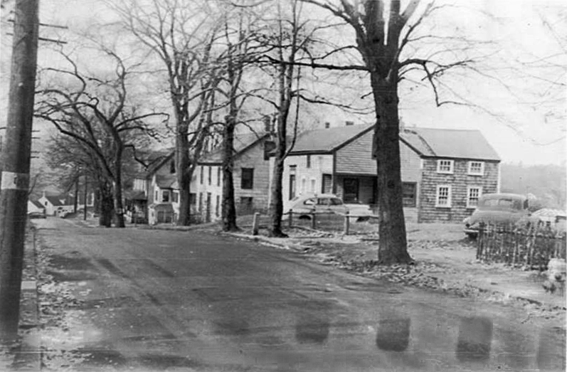
The 1896 Sanborn map of Pearson St. clearly shows three dwelling houses on this parcel, houses #21, #23 and #25. It would appear that #23 was the first to be constructed, # 25 next and #21 a narrow 1½ story dwelling may have been moved here and converted into a tenement. Perhaps an ell off another home nearby.
The 1920 Andover Valuation lists Wm. P. Reagan of 296 Essex St. in Lawrence with the following property assessments on Pearson St. Block, Crystal Palace, #11 - #13, $1600, ¼ a $1500. House #21 $800, House #23, #25 $1600, 5/16 acre $950, House #18, #20 $2500 1/8 acre $350 = $9300.
Regan had a mortgage with the Andover Savings Bank that was later foreclosed on in September 1935 during the end of the great Depression. The bank held the property for two years then sold to Edward & Margaret Vannett on Feb. 16, 1937. Sadly Margaret Vannett died on May 19, 1939.
Edward then sold the home to Charles W. & Alma Dwyer on Sept. 5, 1939. The Dwyer family held the property for 59 years. Charles died on Dec. 13, 1976 and Alma deeds to son Edward F. and wife Florence Dwyer on Jan. 20, 1977. The Town of Andover purchased the property from Dwyer on Oct. 7, 1998 and the house was later razed for a second egress on to Pearson St. from the Safety Center.
Bibliography/References:
Essex Northern Registry Deeds, Lawrence, MA
Essex County Registry Deeds, Salem, MA
Sanborn Map 1896
Andover maps, 1830, 1852, 1872, 1888, 1906
Andover Valuation Schedules, 1850, 1860, 1870, 1920
21 Pearson aka 19 Pearson.
Owners;
Rev. Eliphalet Pearson
Rev. Eliphalet Pearson estate, Sept. 12, 1826, Ephraim Abbot & Stephen Gardner, Trustees
Joshua H. Ward, Esq. – Feb. 26, 1835 – b. 281 leaf 34 - $1267 – 23 lots
Joseph Rice – Aug. 28, 1841 – b. 330 leaf 194 - $50
Mathew Culley – Nov. 3, 1844 – b. 350 leaf 142 - $130
John O. Regan - Feb. 27, 1855 - b. 509 leaf 215 - $250 Salem deeds
John O. Regan estate, Daniel D. & William P. Reagan, trs. - Feb. 12, 1888
James Murphy - Jan. 24, 1895 - b. 444 p. 275 - 4 parcels
William P. Reagan - Jan. 29, 1895 - b. 444 p. 277 - 4 parcels
William P. Regan - July 30, 1921 - b. 444 p. 279 mtg. ASB
Andover Savings Bank - Sept. 17, 1935 - b. 593 p. 347 foreclosure
Edward & Margaret Vannett - Feb. 16, 1937 - b. 605 p. 88
Charles W. & Alma Dwyer - Sept. 5, 1939 - b. 625 p. 331
Alma Dwyer - Dec. 13, 1976 probate of Charles
Edward F. & Florence B. Dwyer - Jan. 20, 1977 - b. 1301 p. 770
Town of Andover - Oct. 7, 1998 - b. 5202 p. 87
Portion of property to Town of Andover - July 31, 1945 - b. 675 p. 124 Lewis St.
Inventory Data:
| Street | Pearson St |
| Place | Andover Center |
| Historic District | Not Applicable |
| Historic Name | John O. Regan property |
| Present Use | Safety Center parking lot |
| Original Use | residence |
| Construction Date | 1855 |
| Source | ERDS, ENRDL |
| Architectural Style | Other |
| Foundation | stone/granite/brick |
| Wall/Trim | Clapboard/wood |
| Roof | asphalt/gable |
| Outbuildings / Secondary Structures | Main house at #21, two other homes at #19 and #23 |
| Major Alterations | Not known |
| Condition | Razed |
| Demolition Details | Mid 20th century |
| Acreage | 0.26607 |
| Setting | commercial/business |
| Map and parcel | 38-8 |
| Recorded by | James S. Batchelder |
| Organization | Andover Preservation Commission |
| Date entered | Jan. 9, 2015, 6/12/2018 |


