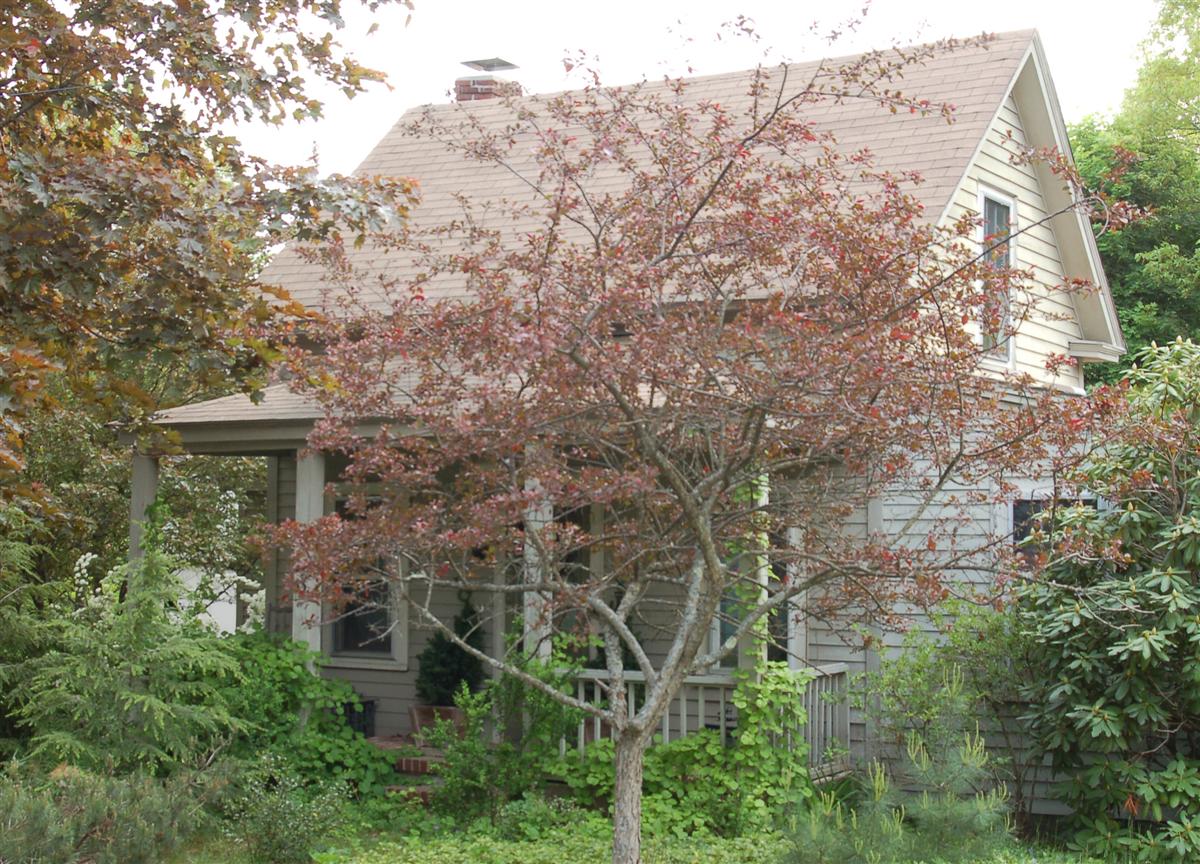
Architectural Description:
Modified Cape style cottage, built as a camp, it has nice proportions and simple cottage charm with front porch across the front facade.
Historical Narrative:
Boston Road has had several names through the years including, Old County Rd (1915), Foster’s Pond Rd. 1930-1935, Old Boston Road and then Boston Rd. by 1937. Deeds can be confusing at first and street directories misleading as we now have a County Rd and Foster’s Pond Rd adjoining Boston Rd. What appears as a move to another street is actually a street name change. Andover Valuation Schedule add to the issue by listing the road as Main St. This area is in the South District in the Valuation lists and within the Scotland School District from 1785-1902. Only one house is listed on the road in 1906 at #5. With development came an influx of French Canadians who purchased lots on Boston Rd. It was sometimes referred to as “Frenchville” by locals.
This property was once owned by Rufus Caldwell and was part of his 75 acre farm. His house was located east of Boston Rd. between So. Main St. His estate was auctioned off after his death in October 1891. The property was purchased by Brooks F. Holt for $1500. Brooks F. home was on South Main St. and he was an Ice Dealer in town. Brooks later sold his business and began selling off parcels of the former Caldwell farm.
Fred Richards purchased this property of one acre from Brooks F. Holt on April 20, 1916. Fred built the house; The 1920 Andover Valuation South District lists Fred Richards, Main St. - Camp $600, 1 acre land $75 = $650. valuation. Fred and wife Angelina "Annie" lived here until 1946 when Fred divided up the property into four lots and sold this lot #3 House to his brother-in-law of George Bernard and wife Rose (Richards).
Fred sold the middle two lots to Francis J. Richards on Nov. 2, 1946 and retained the home at 39 Boston Rd. lot #1 on the 1950 map. George Bernard is the son of Maggie Bernard of #29 Boston Rd.. George Bernard owned 8 years then sold to Ivan A. Tanner on June 25, 1954. Tanner must have rented the property for in the 1961 Street Directory #33 is occupied by Frank & Eva Jacobi. Frank b. 1886 is retired and wife Eva b. 1897 is a housewife.
Tanner sells to Paul W. & Helen R. Holter on May 9, 1969. The Holters owned for 27 years then sold to Donna Laconti on Jan. 12, 1996. Donna Laconti owned for 19 years. David & Allison Guerette purchased on Sept. 28, 2015 and are now owners of record.
Bibliography/References:
Essex County Registry Deeds, Salem, MA
Essex Northern Registry Deeds, Lawrence, MA
Map plan #1804 - Oct. 1946
Map plan #2273 - Aug. 16, 1950 - lots 1, 2, 3
Owners:
Rufus Caldwell estate, Albert W. Caldwell Adm. - June 1, 1891 - Probate
Brooks F. Holt - Nov. 9, 1891 - b. 116 p. 41
Fred Richards, wife Angeline - Apr. 20, 1916 - b. 363 p. 174 - 1 acre
George Bernard, wife Rose (Richards) - Nov. 2, 1946 - b. 691 p. 455
Ivan A. Tanner - June 25, 1954 - b. 798 p. 36
Paul W. & Helen R. Holter - May 9, 1969 - b. 1130 p. 109
Donna Laconti - Jan. 12, 1996 - b. 4417 p. 216
Boston Road Realty Trust, Donna Laconti Tr. - Dec. 18, 2002 - b. 7368 p. 66
Boston Road Realty Trust, Donna Laconti Tr - Apr. 23, 2003 - b. 7835 p. 133
Donna Laconti - June 2, 2006 - b. 10216 p. 193
Boston Road Realty Trust, Donna Laconti Tr - July 5, 2006 - b. 10281 p. 205
David & Allison Guerette - Sept. 28, 2015 - b. 14393 p. 144
Inventory Data:
| Street | Boston Rd |
| Place | Scotland District |
| Historic District | Not Applicable |
| Historic Name | Fred & Angeline Richards Cottage |
| Present Use | residence |
| Original Use | residence |
| Construction Date | 1916 - 1918 |
| Source | ERDS, NERDL, style, |
| Architectural Style | Other |
| Foundation | brick/stone |
| Wall/Trim | clapboards/wood |
| Roof | asphalt/gable |
| Major Alterations | additions to side and rear over the years |
| Condition | good |
| Acreage | 0226 acre, 9,860 sq. ft. |
| Setting | residential |
| Map and parcel | 83-56 |
| Recorded by | James S. Batchelder |
| Organization | Andover Preservation Commission |
| Date entered | 01/30/2006, 4/28/2018 |

