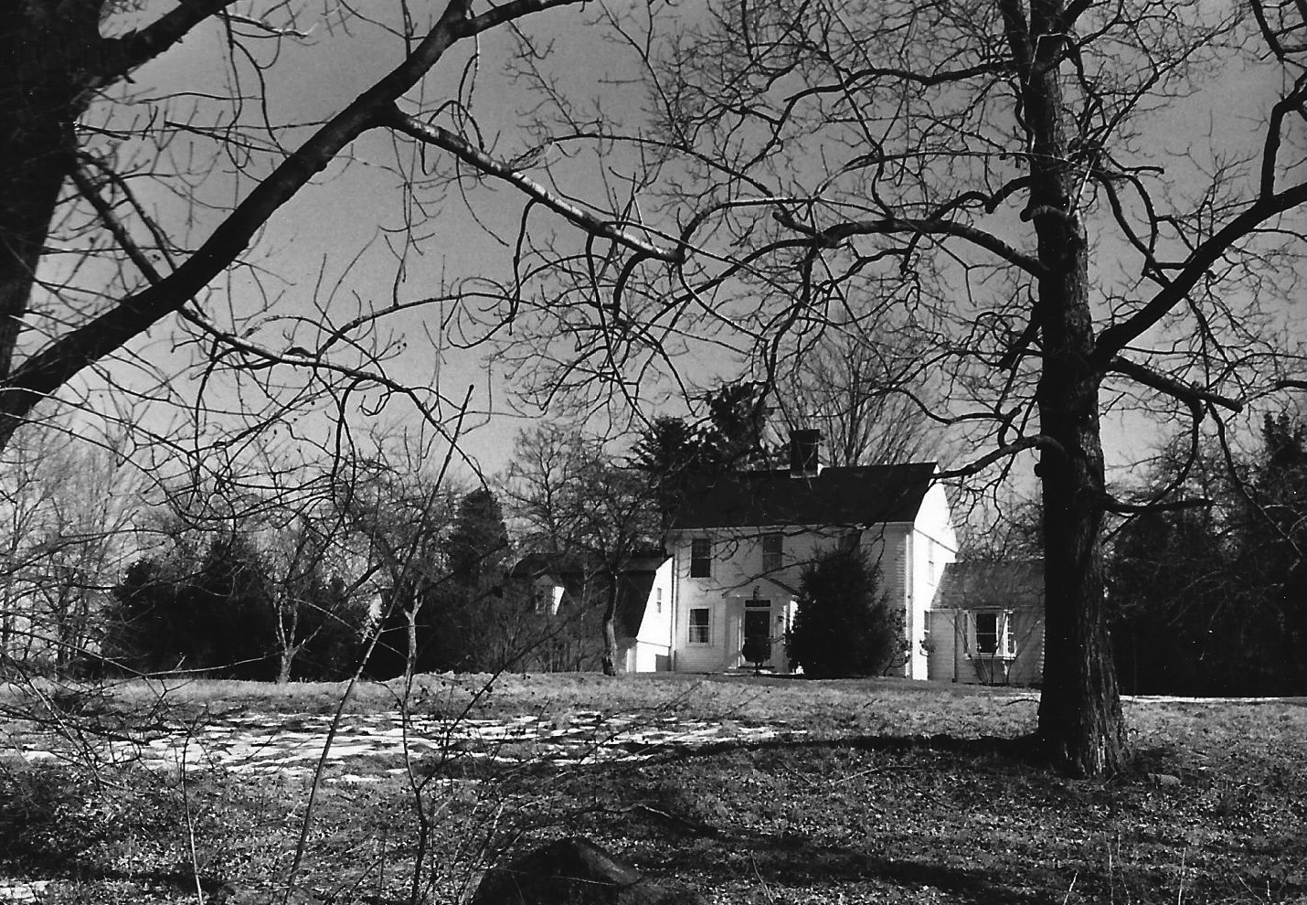
Architectural Description:
3-bay facade; projecting 3rd story at gable end; sculptured center chimney; 12/12 sash; classical center entry vestibule
Historical Narrative:
Themes: architectual, community development
This property was once part of the Pearson Farm on Main St. located where the new Phillips Academy hockey rink complex was built. The farm was acquired from Margaret W. Pearson in 1922 by Arthur Sweeney and then the Trustees of Phillips Academy . This parcel "lot B" , and lot "C" was the southwest portion of the Pearson Farm and was sub-divided into three lots, the greater portion "lot A" remaining with the farmhouse lot at 254 South Main St. The Trustees of Phillips Academy created the sub-division with deed restrictions as to number of homes built and reserved right to purchase back at time of sale.
The two lots B & C were then sold to Helen K. McLanathan, wife of Frank K. who were residing at 111 Main St. at that time. It appears the the McLanathan family built the home at 10 Bancroft. Rd. Guy Lowell is the attributed architect of the home. Guy Lowell also redesigned the Phillips Academy Campus in the mid 1920's. The 1926 Andover street directory lists Frank & Helen at the Bancroft Rd. address. Frank had a leather business in Lawrence, MA. In 1935 McLanathn had moved to Lawrence, temporarily and the house was leased to Vasco & Edith R. Nunez, a manufacturer from Nashua, N.H.
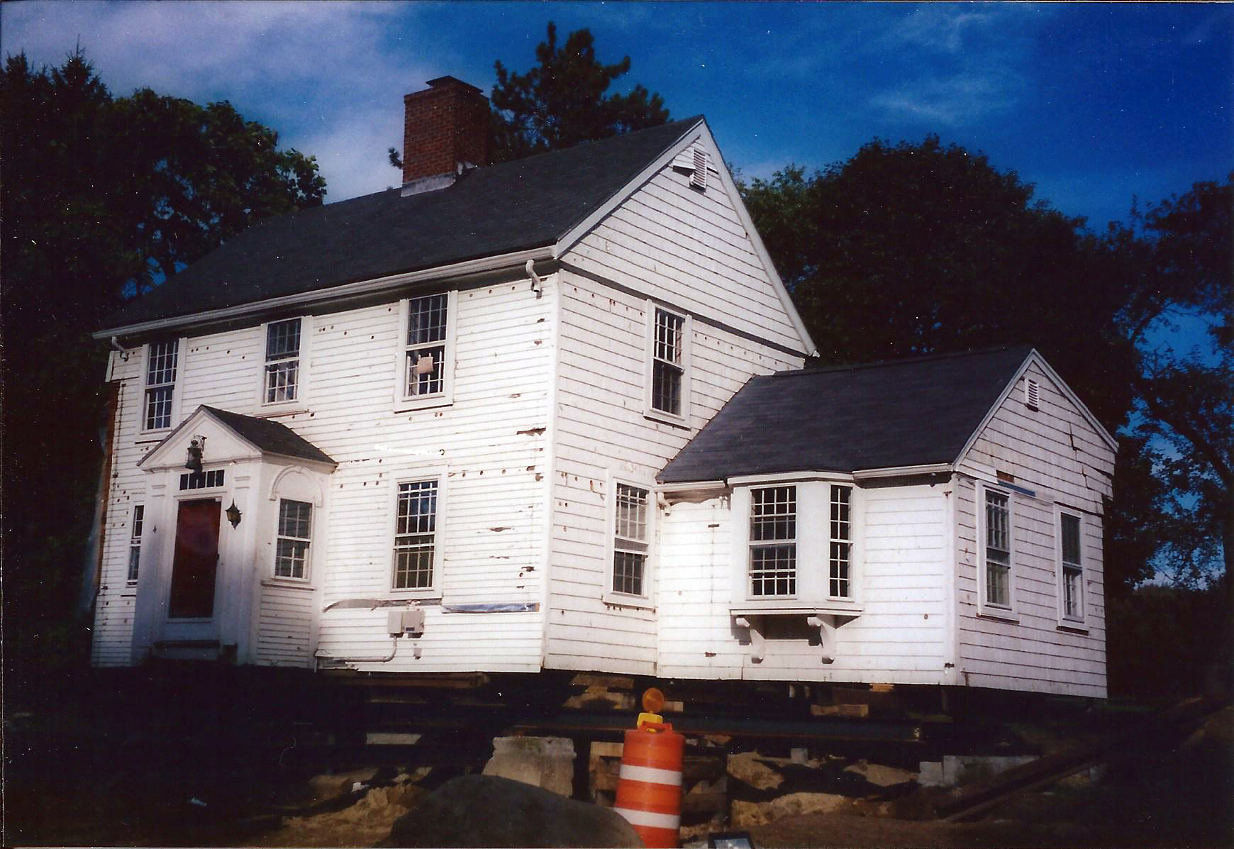
McLanathan then built the Colonial Revival home on lot B. to the rear of this property in 1936, now #4 Bancroft Rd. This house was built as a Colonial reproduction. The McLanahans are residents in the home in the 1937 Andover Street Directory. McLanathan family owned this home for 30 years. The estate was sold to David R. & Anne T Kneeland on Jan. 27, 1961. Dr. James W. & Mette K. Skillings purchased the home on Apr. 5, 1966 and owned for 35 years. The property was sold in 2001 to James D. Berberian and the lot was sub-divided 2005. The house was moved in the Spring of 2006 and turned 180 degrees to face east. The garage and bedroom above were razed at the time of the move and new wings added at the new site.
1980 survey description: Very simple design highlighted by center chimney and entry vestibule, elegant windows, impressive, isolated setting. Possibly remodeling of earlier building, or a good reproduction.
Bibliography/References:
Essex County Registry Deeds, Salem MA
Essex Northern Registry Deeds, Lawrence, MA
Land Court - Map plan #8667-A - Feb. 1, 1922 - Pearson Farm
Land Court - Map plan #8667-B - 1936 -
Land Court - Map plan #8667-C
Land Court - Map plan #8667-D - Jan. 1966 -
Land Court - Map plan #8667-E
Owners:
Margaret W. Pearson - May 4, 1922 - Certificate #1105 - land court
Arthur Sweeney, wife Mildred L. - May 13, 1922 - Ctf. #1111
Trustees of Phillips Academy -
Helen K. McLanathan, wife of Frank W. - Feb. 28, 1936 - Ctf. #2152 - lot B
Helen K. McLanathan estate, Frank W. heir
Frank W. McLanathan estate, Rebecca W. McLanahan - 1961
David R. & Anne T. Kneeland - Jan. 27, 1961 - Ctf. #5026
James W. & Mette K. Skillings - Jan. 20, 1966 - Ctf. #5807
James W. & Mette K. Skillings - Ctf. #12279
James D. Berberian - Aril 19, 2001 - Ctf. #13635
Trustees of Phillips Academy - June 30, 2014 - Ctf. #17121
Inventory Data:
| Street | Bancroft Rd |
| Place | Phillips District |
| Historic District | Not Applicable |
| Historic Name | McLanathan House |
| Present Use | residence |
| Original Use | residence |
| Construction Date | 1936 |
| Source | ECRDS, ENRDL |
| Architectural Style | Colonial Revival |
| Foundation | stone |
| Wall/Trim | clapboards/wood/vinyl siding |
| Roof | asphalt - gable |
| Outbuildings / Secondary Structures | none |
| Major Alterations | Garage and ell removed 2001 when house relocated to present site. |
| Condition | excellent |
| Moved? | Yes |
| Move Details | 2006 - moved closer to S. Main St. |
| Acreage | 1.232 acres |
| Setting | residential |
| Map and parcel | 58-23B |
| MHC Number | ANV.606 |
| Recorded by | W. Frontiero/J. Batchelder |
| Organization | Andover Preservation Commission |
| Date entered | 2/26/80, 2006, 5/3/2016 |


