Architectural Description:
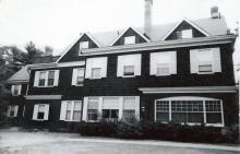
This home was originally constructed in the Shingle Style of natural weathered cedar shingles, stone foundation, gabled roof. An extensive fire destroyed much of the roof and second story. The reconstruction of the building changed the exterior appearance to the current design.
Historical Narrative:
50 Phillips St. Formerly 50 Abbot St. - Once called Woburn St. beginning at the intersection of Phillips St. It was renamed Abbot St extending to Porter Rd. and the new beginning of Woburn St. in 1904.
The house on the southwest corner of Abbot and Phillips Street was built by Susanna Ward Smith in the 1890’s. This property was once owned by John H. Abbot and was comprised of two parcels; one of 9 acres on the north end, once owned by John Abbot and the second parcel of about 3 acres on the south end of David P. Abbot of which John H. Abbot was an heir. John H. & wife Jessie L. Abbot were living in Big Spring, Nebraska when he sold the 12 acre lot to Frances A. Flint, wife of John H. Flint of Andover, MA.
Frances Flint held the vacant property for a year before selling to Susanna Ward Smith. Susanna W. was born on Dec. 12, 1843, the daughter of Peter & Esther (Ward) Smith. Her father was one of the founders of the Smith & Dove Manufacturing Co. and one of the wealthiest families in Andover. Susanna’s father died in 1880 and her mother died in May 1889. Her inheritance may have funded the construction of a house of her own at this site. Susanna had always lived with her parents in the Forest Hill estate on Shawsheen Road.
The original house was designed in the Shingle Style, with gable dormers on the front, natural cedar shingles with stone foundation and brick chimneys all to create visual texture yet anchored within the natural landscape. The former Andover & Wilmington Railroad line (1838-1848) ran along the south side of Abbot Street and crossed the road at this intersection in front of the house lot. The old railroad bed acted as a long lane for pedestrians to stroll on their way to Pomp’s Pond or Spring Grove Cemetery.
On December 6, 1899 Susanna Smith sold the house and a portion of the property to Anne Middleton Means and her sister Mary McGregor Means. Susanna then moved to Boston. The Means sisters co-owned the property. Anne was born June 30, 1843 in Manchester, NH. Mary McG. born in 1849. They were the daughters of William Gordon Means & Martha (Allen) Means. The Means family moved to Andover in the 1850s and William lists his occupation as Treasurer of a Manufacturing Co. They had six children. Means had moved to 248 Commonwealth Ave in Boston by 1880 and is now a locomotive manufacturer. Their mother Martha died in 1892 and William died in 1894. Anne and Mary continued to live in the Back Bay townhouse of their parents. This home in Andover may have served as a summer house. With the death of Mary in 1904 the remaining estate went to Anne Means. When Anne died in 1923 her estate was handled by Executors, Alfred L. Ripley and Marcus Morton Jr. The Means family are interred at South Church Cemetery.
The property was sold to John T. and Annie B. Lord of Lawrence, MA on Feb. 16, 1925. The Lord family held the property for three years then sold to E. Barton & Jeannette T. Chapin on Apr. 6, 1928. Barton and Jeannette Chapin lived at 47 Abbot St. Edward Barton Chapin was the son of Edward P. & Cornelia A. (Smith) Chapin who lived up the hill on Phillips St at 38 Phillips St. E. Barton Chapin was born July 13, 1885 in Providence RI. He was a Lawyer and worked in Boston. There was a disputed boundary line between this property and the Castle property next door at 54 Abbot Street. The Chapin family facilitated an agreement on the boundary line on May 1, 1950 recorded in b. 734 p. 585.
The Chapins owned the property until Barton’s death in Nov.1967. Jeannette O. Chapin then sold the property to the Trustees of Abbot Academy on Oct. 31, 1968. Jeanette died and was interred on April 6, 1974 in the Chapin family lot in Spring Grove Cemetery.
Abbot Academy used the house as a dormitory. With the merger with Phillips Academy in February 1973 the property holdings of Abbot were transferred over the Phillips Academy on July 2, 1973.
The house was heavily damaged by a fire and the upper story and roof were rebuilt. The original Shingle Style home was changed to the current configuration. The former carriage house that was sited to the rear of the property was lifted up turned to face Phillips Street and converted into faculty housing.
Bibliography/References:
Essex County Registry Deeds, Salem, MA
Essex Northern Registry Deeds, Lawrence, MA
Ancestry.com Smith & Means family
Federal Census records
West Parish Garden Cemetery burial records
South Church Cemetery burial records
Owners;
John H. Abbot – 1888 – two parcels of land 12 acres
Frances A. Flint, wife of John H. Flint – Jan. 1, 1889 – b. 98 p. 547 – 12 acres land
Susanna W. Smith – Jan. 25, 1890 – b. 105 p. 10 – 12 acres
Anne M. Means & Mary McG. Means 0 Dec. 6, 1899 – b. 174 p. 139
Anne M. Means estate, Alfred L. Ripley Extr. – Feb. 12, 1925 – Probate
John J. & Annie B. Lord – Feb. 16, 1925 – b. 509 p. 487
E. Barton & Jeannette T. Chapin – Apr. 6, 1928 – b. 539 p. 232
E. Barton Chapin estate – Oct. 23, 1968 Probate #294536
Jeannette T. Chapin – Oct. 23, 1968 – 1118 p. 190
Trustees of Abbot Academy – Oct. 31, 1968 – b. 1118 p. 192
Trustees of Phillips Academy – July 2, 1973 – b. 1222 p. 85
Inventory Data:
| Street | Phillips St |
| Place | Phillips District |
| Historic District | Not Applicable |
| Historic Name | Smith-Means-Chapin house |
| Present Use | Resdence - dormitory |
| Original Use | residence |
| Construction Date | 1890s |
| Source | ERDS, ENRDL |
| Architectural Style | Shingle |
| Foundation | stone & granite |
| Wall/Trim | shingle/wood |
| Roof | asphalt |
| Outbuildings / Secondary Structures | Carriage house - converted to residence |
| Major Alterations | Reconstructed after fire 1970s? |
| Condition | excellent |
| Acreage | 4.29 acres |
| Setting | Residential/Educational |
| Map and parcel | 56-14 |
| MHC Number | ANV.11 |
| Recorded by | Stack/Mofford, James Batchelder |
| Organization | Andover Preservation Commission |
| Date entered | 1975-77, 12/2014 |


