Architectural Description:
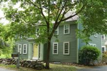
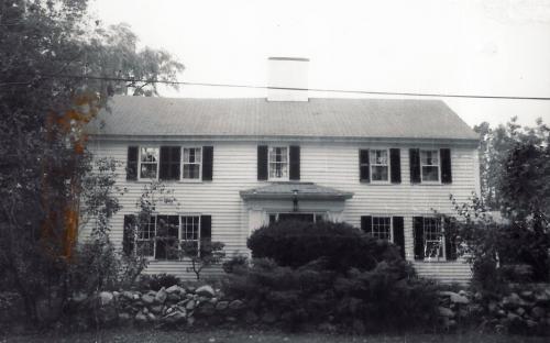
Federal vestibule - asymmetrical facade - probably very early - A frontal view of the home shows the front vestibule slightly off center to the east. This suggests that the home was built first as a half house and later enlarged to a full five bay facade. Spacing of the paired windows on the west end are closer than those on the east side. Center window on second floor off center to door below.
Historical Narrative:
Themes - Agricultural, Architectural and Community Development.
June 1986 nominated to the National Register of Historical Places by Boston University's thematic nomination on first period houses in Essex County.
This Homestead was once owned by Capt. Moses Abbott. Moses was born Aug. 9, 1735 in Andover, MA son of Barachias & Hannah (Holt) Abbott. Moses married on Dec. 31, 1761 to Elizabeth Holt b. June 8, 1743 dau. of Henry & Rebecca (Gray) Holt of Andover. Moses & Hannah had eleven children: Rebecca 1763-1844, Moses Jr. 1765-1813, Elizabeth 1768-1829, Noah b. May 11, 1770 –d. July 13, 1849, Hannah b.1772-1772, Enoch b. Apr. 8, 1774 – d Sept. 26, 1842, Rhoda Ann 1776-1827, Henry 1778-1845, Jacob 1781-1836, Abigail 1783-1827, and Phoebe 1786- ? Moses Abbott served as a Lieutenant in the French & Indian War. Moses was a Yeoman, or farmer, surveyor and a schoolmaster. Moses built his homestead on Stinson Road. Moses died Feb. 23, 1826 and his widow Hannah seven years later on Sept. 23, 1833.
Two sons, Noah Abbott b. May 11, 1770 and Enoch Abbott b. Apr. 8, 1774 would end up dividing their father’s farm. Noah took the east section of the farm and the house at 22 Stinson Rd and Enoch bought the west section and homestead at 6 Stinson Rd.
Enoch Abbott married July 4, 1799 to Nancy Flint b. Sept. 19, 1777 in Danvers, MA daughter of Samuel & Ede (Upton) Flint, Jr. Enoch & Nancy had nine children: Henry 1799-1878, Nancy 1801-1862, Sophronia 1803-1898, Enoch Jr. 1804-1891, Benjamin Flint 1809-1886, Rebecca Holt 1811-1862, Samuel Flint 1814-1843, Rhoda Ann 1817-1900 and Bushrod Washington 1821-1853. Enoch paid $1000 to his brother Noah on May 9, 1842 for his portion of the farm. It included the homestead lot of 16 acres, the 26 acre lot across the street and seven addition parcels. Noah paid $1000 for 21 acre part of Moses Farm with buildings and five additional parcels. Sadly Enoch died on Sept. 26, 1842. The estate went to his wife Nancy and remaining children who later sold to Jonas Holt for $2050. Holt then sold to Sarah R. M. Hiler of Marblehead, wife of Rev. Stephen G. Hiler. Widow Nancy then lived with her daughter Sophronia, wife of David Gray.
The Abbott heirs sold two years later on May 6, 1844 for $2050 to Jonas Holt., the 16 acre homestead lot and the 28 acre lot. Holt then transferred the title to Sarah R. M. Hiler, wife of Rev. Stephen G. Hiler, of Marblehead, MA on May 6, 1844. The 1850 Andover Valuation schedule lists Stephen G. Hiler Jr., Dwelling house $450, barn & other building $175, 11 acres adjoining buildings $495, 33 acre pasture $594 and Farm stock $137. Rev. Hiler was the first minister of the Methodist Episcopal Church of (North Parish 1845-1846 and then the Ballardvale Methodist Church organized in 1850. Hiler also married Eliza Augustus Abbott to Henry C. Higgins on Oct. 15, 1853. Hiler owned the farm for ten years then selling to George Worcester of Chelmsford, MA on May 10, 1854. The 26 acre lot across the street was sold off by Hiler in 1852. (see 3 Stinson Rd)
George Worcester owned until his death 14 years later. His heirs Phebe J. Jenkins, N. Attilia Worcester, Mary C. V. Worcester and George F. Worcester then sold to Jaques Gowing, of Reading, MA, wife Mary on Apr. 25, 1868 for $1950. Jagues Gowing served during the Civil War as a Private in Companies K 36th Mass. Inf. D 56th Mass Inf. and A 21st Mass. Infantry. Jaques farmed the land for 5 years then returned to Reading, MA
Rufus W. Damon, wife Sarah B. of North Reading purchased the farm on Oct. 10, 1873 for $2050. Damon held for eight years then sold to Joseph Johnson, wife Catherine on Feb. 22, 1881. Johnson took a mortgage from Joseph J. Pearson on May 31, 1882 for $1200. This mortgage was sold and transferred several times through a variety of mortgage deed exchanges due in part to deaths and POA assignments. The mortgage also transferred to the new owners making for a complicated ownership line.
Lydia Kimball acquired ownership of the homestead on Apr. 22, 1890. with 14 acre parcel. Lydia's health may have been failing at that time as she transfers the deed to George M. Kimball of Haverhill on Sept. 29, 1891. George Kimball signs a Bond with Lydia to take care of her, in her property, or if needed another location in Oct. 9, 1891. George Kimball later sells the property to Edward Sprague on June 7, 1893 and Sprague to Ernest E. Myers, wife Elizabeth on Dec. 4, 1893.
Elizabeth Myers held the deed and later sells to H. Bradford Lewis on Sept. 11, 1905. Lewis refers to deed issues when he attempts to sell under an Agreement, but later cancels the deal. Margaret T. Connor of Lawrence purchased the 14 acre property on June 3, 1912. Connor then Petitions the Land Court on June 10, 1912 for clear title to the property and its boundary lines. Notice of Disposal via Land Court to Margaret T. Connor, wife of Thomas F. on Sept. 20, 1912 - Certificate #363
Lester W. & Sarah M. Hough then purchased the property on June 21, 1915. Next owners were David D. & Nellie C. Black on Apr. 15, 1919 for 27 years then George F. Sawyer, wife Isabelle D. on Aug. 2, 1946. The Sayers sold to Paine Realty Trust, Helen F. & Palmer B. Worthen Jr. Trustees on Aug. 6, 1960. The 14 acre homestead lot was then sub-divided and the homestead lot was reduced to 1.4 acres on the SW corner of the original parcel. With the new deed was a restriction never to sub-divide the homestead lot again.
The Plan map #3880 - A in 1912 shows the house with attached ells and barn to the west of the house extending to the corner of Holt Rd. The map in #3880 - B 1961 shows the shed and barn moved to the east side of the home.
Past research on the home suggest that the following: land assessed to James Stinson 1870 and Mrs. Elizabeth Stinson, 1888. Included 25 acres of land, house, shed and barn. He formerly had house and shop on Salem Street (1852 map). On 1856 map, his house is cited here off Holt Road. This may be in error or miss labeled on the maps. More research needed to confirm.
Bibliography/References:
Essex County Registry Deeds, Salem, MA
Essex Northern Registry Deeds, Lawrence, MA
Andover Historical Society files
Goldsmith, Bessie; Townsman's Andover, 1964, p. 91
Maps of Andover, 1852, 1856, 1872, 1884, 1888 maps
Owners:
Essex County Registry Deeds, Salem, MA
Essex Northern Registry Deeds, Lawrence, MA
Map plan #3880 A - May 1912 - Plan of land - Connor
Map plan #3880 B - Feb. 4, 1961 - Sub-division
Owners;
Moses Abbott, wife Elizabeth - b. 1735 d. Feb. 23, 1826
Moses Abbott, estate, Elizabeth heir downer 1826
Elizabeth Abbott estate - died Sept. 23, 1833
Abbott heirs;
Noah Abbott, wife Hannah - 1842
Enoch Abbott, wife Nancy - May 9, 1842 - b. 333 leaf 78 - $1000. - 9 parcels of land
Enoch Abbott estate, died Sept. 26, 1842, heir wife Nancy
Noah Abbott - Sept. 27, 1842 - b. 333 leaf 224
Enoch Abbott heirs; Wid. Nancy, Enoch, Sophrenia, Bushod W. Abbott, Sam S. & Rhoda Richardson, Rebecca H. Foster & Benj. F. Abbott
Jonas Holt, wife Pamelia - May 6, 1844 - b. 346 leaf 290 - $2050 - two lots, 16 acre homestead lot, 28 acre lot
Sarah R. M. Hiler, wife of Stephen G. Hiler - May 6, 1844 - b. 346 leaf 291 - $2300 two lots
George Worcester - May 10, 1854 - b. 494 leaf 224 - $800
George Worcester estate, heirs: Phebe J. Jenkins, N. Attilia, Mary C. V., and George F. Worcester - 1868
Jaques Gowing, wife Mary - Apr. 25, 1868 - b. 746 leaf 49 - $1950
Rufus W. Damon, wife Sarah B. - Oct. 10, 1873 - b. 24 p. 185 - $2050
Joseph Johnson, wife Catherine - Feb. 22, 1881 - b. 62 p. 582
Joseph J. Pearson - May 31, 1882 - b. 68 p. 287 - mtg deed - $1200
Lydia Kimball - Apr. 22, 1890 - b. 106 p. 231
George M. Kimball - Sept. 29, 1891 - b. 115 p. 203 - Bond $1000
George M. Kimball - Oct. 9, 1891 - b. 115 p. 440
Edward Sprague - June 7, 1893 - b. 126 p. 15
Ernest E. Myers, wife Elizabeth - Dec. 4, 1893 - b. 129 p. 491
Joseph Thompson - Aug. 27, 1901 - b. 188 p. 20 mtg
Elizabeth Myers to H. Bradford Lewis - Sept. 11, 1905
Margaret T. Connor - June 3, 1912 - b. 317 p. 441 - deed 14 acres
Margaret T. Connor - June 10, 1912 rec July 12, 1912 - b. 319 p. 353 Notice of Petition
Margaret T. Connor - Sept. 20, 1912 - b. 321 p.530 - Notice of Disposal -Land Court
Margaret T. Connor, wife of Thomas F. - Sept. 20, 1912 - Certificate #363
Clover J. Stone - May 3, 1914 - b. 353 p. 584
Lester W. & Sarah M. Hough - June 21, 1915 - Ctf. #474
David D. & Nellie C. Black - Apr. 15, 1919 - Ctf. #780
George F. Sawyer, wife Isabelle D. - Aug. 2, 1946 - Ctf. #3116 - 14 acres
Paine Realty Trust, Helen F. & Palmer B. Worthen Jr. Trs. - Aug. 6, 1960 Ctf. #4988
Carolyn P. Butler & J. Kenrick Butler - Feb. 20, 1961 - Ctf #5038 - 1.4 acres
Carolyn P. Butler estate, John K. Butler, Carolyn L. Dow Extrs.
Peter B. & Shirley Schwarz - June 17, 1996 - Ctf. #12463
Bruce M. & Nancy Cho Landay - June 27, 2011 - Ctf. #16509
Inventory Data:
| Street | Stinson Rd |
| Place | Holt District |
| Historic District | Individual National Register Listing |
| Historic Name | Abbot-Stinson Farm |
| Present Use | residence |
| Original Use | farm and residence |
| Construction Date | 1720-1726 |
| Source | ECRDS, ENRDL, style-njs |
| Architectural Style | Georgian |
| Foundation | stone/granite |
| Wall/Trim | clapboards/wood |
| Roof | asphalt - gable |
| Outbuildings / Secondary Structures | garage right of house |
| Major Alterations | minor remodeling in 1976, rear addition and attached garage - 1990's |
| Condition | excellent |
| Moved? | Yes |
| Move Details | barn and attached ells |
| Acreage | 1.417 acre, 36,196 sq. ft. |
| Setting | residential |
| Map and parcel | 42-42 |
| Recorded by | Stack/Mofford, James S. Batchelder |
| Organization | Andover Preservation Commission |
| Date entered | 1975-77, 3/25/2016 |


