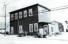
Architectural Description:
Late Greek/Italianate Vernacular
Nearly flat roof pitch
Historical Narrative:
Themes: Architectural, Community Development, and Industry
Pearson Street was named for the Rev. Eliphalet Pearson, L.L., D born 1752 in Byfield, Newbury, MA, graduate of Harvard in 1773, taught at Andover Grammar School in 1774, first Principal of Phillips Academy 1778-1786. In 1806 he helped found the Andover Theological Seminary. Pearson moved to Harvard, MA in 1820 and died on Sept. 12, 1826.
It should be noted that the B&M Railroad had not yet been built, opened in 1848., but the Andover - Wilmington Railroad line 1838-1848 did cross on the upper east end of Pearson Street.
This property on Pearson St. was once owned by Rev. Eliphalet Pearson. Pearson's land in Andover was sold by Trustees of his estate, Ephraim Abbot and Stephen Gardner to Amos Abbott on Sept. 30, 1830 and is the 3rd lot mentioned in the deed measuring 70’ on Pearson St. x100’ x 70’ x 100’. Amos Abbott's other lots abut his dwelling house on the south corner of Pearson & No. Main and Pearson's garden.
The former building on this site was probably originally associated with Andover and Wilmington Railway 1838 - 1848, then acquired by Boston and Maine Railroad. The house was razed in 1985 after the property was purchased by the Town of Andover for public library expansion and parking.
Now the Pearson St. entrance to the Memorial Hall Library parking lot, the right of way was once called Essex Place. The drive through the parking lot was the railroad bed for the Andover - Wilmington Railroad that connected through to Haverhill. The tracks continued across North Main Street through Hartigan Court and down what is now High Street to North Andover Center.
The railroad tracks were relocated in 1847 to the current location of the Boston & Maine Railroad line to service the new city of Lawrence, MA, then reconnected at North Andover and on to Haverhill.
The old Andover Playhouse movie theater on Essex St. was the former train Depot which was razed for the new library rear addition in the 1980s.
After the railroad change the property was purchased by Jacob Chickering along with some of the railroad buildings and was used for his carpentry shop and later piano factory.
Chickering sold his carpentry business to Moses Clement & George L. Abbott on March 5, 1863. "Clement & Abbott" built several homes and business buildings in Andover in the years that followed. After Clement's death, Abbott joined in partnership with William Jenkins in the firm of "Abbot and Jenkins" until George Abbott's death in 1889. William Jenkins then sold the property and business to Lewis Hardy & Joseph F. Cole of "Hardy & Cole". Hardy and Cole acquired the Joseph Low estate at 70 North Main St. in 1892 and shifted their business operations to that property creating Lewis St. and Buxton Ct. The Town Yard now occupies much of the former Low estate.
This property and the former shop buildings were sold to George F. Smith, President of the Smith & Dove Manufacturing Co. in 1915. S&D Co. was in need of operative housing and some buildings were rented for that purpose. It may be that this building was converted into apartments at this time.
This building was sold to John Dagdigian & Bagdasar Ozoonian in March 1922 and then to Paraphon Ozoonian and Avedis Ozoonian in trust in June 1922.
The men were starting a shoe shop business at this time. A mortgage was taken with the Andover Savings Bank in Feb. 1924 but later defaulted and the bank took the property in Nov. 1927.
Walter & Belinda Beck purchased the property from the bank on May 17, 1928 and held the property until March 1935. The Great Depression took its toll and many families and the Becks lost the property to the Andover Savings Bank at that time. The property was held for seven years before the bank sold to Clifford E. & Ruth S. Marshall on Jan. 9, 1943.
Marshall held the property for 17 years renting the apartments. The sold to William F. & Georgina Lane on Feb. 2, 1960. Lane held for 24 years before selling to the Andover Memorial Hall Trustees on Dec. 20, 1984.
Bibliography/References:
Essex County Registry Deeds, Salem, MA
Essex Northern Registry Deeds, Lawrence, MA
Owners.
Rev. Eliphalet Pearson
Rev. Eliphalet Pearson estate, Sept. 12, 1826, Ephraim Abbot & Stephen Gardner, Trustees
Amos Abbott – Sept. 30, 1830 – b. 262 leaf 20 – 3rd lot 100’ x 70’ x 100’ x 70’, west of Foster’s land
Andover & Wilmington Railroad - 1838 - 1848
Boston & Maine Railroad – 1848 - 1852
Jacob Chickering – Mar. 23, 1852 – b. 464 leaf 157 - $1700 – 43,863 sq. ft.
Moses Clement & George L. Abbott - Mar. 5, 1863 - b. 649 leaf 182
George L. Abbott & William Jenkins -
George L. Abbott estate, Geo. A. Poor, extr. - Jan 1, 1890 b. 104 p. 488
WiIliam Jenkins - 1/2 business - June 17, 1889 - Abbott probate
Lewis Hardy & Joseph F. Cole - Jan. 1, 1890 - b. 104 p. 486
George F. Smith - Dec. 2, 1915 - b. 359 p. 281
John Dagdigian & Bagdasar Ozoonian - Mar. 2, 1922 - b. 454 p. 109
Paraphan Ozoonizn & Avedis Ozoonian - June 19, 1922 - b. 460 p. 190-192
Paraphan Ozoonizn - Feb. 16, 1924 - b. 496 p. 445
Andover Savings Bank - Feb. 16, 1924 - b. 496 p. 445 mtg
Andover Savings Bank - Nov. 7, 1927 - b. 537 p. 322-324 poss.
Walter & Belinda Beck - May 17, 1928 - b. 541 p. 101
Andover Savings Bank - July 1, 1935 - b. 590 p. 478 - poss.
Clifford E. & Ruth S. Marshall - Jan. 9, 1943 - b. 655 p. 596
William F. & Georgina Lane - Feb. 2, 1960 - b. 910 p. 23
Inventory Data:
| Street | Pearson St |
| Place | Andover Center |
| Historic District | Not Applicable |
| Present Use | residence/3 apartments |
| Original Use | carpentry factory building |
| Construction Date | c.1850 - 60 |
| Source | ERDS, ENRDL |
| Architectural Style | Italianate |
| Foundation | stone and brick |
| Wall/Trim | clapboards/wood |
| Roof | tar & gravel |
| Condition | razed 1985 |
| Demolished? | Yes |
| Demolition Details | early 1985 |
| Acreage | 0.7185 acre; 3,130 sq. ft. 54' frontage |
| Setting | residential/commerical |
| Map and parcel | 55-71A |
| MHC Number | ANV.424 |
| Recorded by | Stack/Mofford, James Batchelder |
| Organization | Andover Preservation Commission |
| Date entered | 1975-77, 1/9/2015 |


