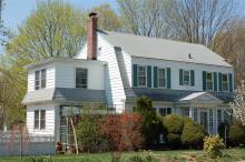
Architectural Description:
Colonial Revival - Dutch Colonial - Nice proportions, similar to homes built in Shawsheen Village during this period
Historical Narrative:
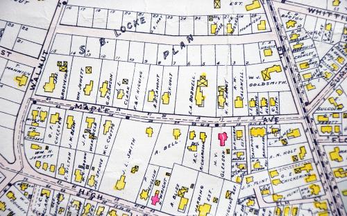
Wolcott Avenue was laid out in March 1902 by engineer John E. Smith Map #96. It is said to have been named for Governor Roger Wolcott former Lt. Governor 1893-1897 and then Gov. from 1897-1900. The street had 29 house lots and was a portion of the 25 acre Samuel B. Locke estate at 70 Elm St. The farm extended down to Maple Ave and was bounded by Walnut and Elm Streets. Anne H. Locke, wife of Samuel B., held the deed on Apr. 12, 1876. Anne sold off some of the first lots on the Ave before naming her daughter Florence M. Locke her Trustee on June 2, 1909. Florence then had charge of selling the remaining house lots. Annie and Florence had life tenancy in the Locke homestead at 70 Elm St.
All the deeds came with restrictions. Only one home per lot, either single or a two family. The home had to cost at least $3000 above the foundation. The cost was later raised to $3500. A set back of 30’ from the street and all garages in the rear of the property. By the 1920’s they restricted one story bungalows.
Wolcott Ave has a diverse mix of styles including modified Queen Anne, Shingle style craftsman, Bungalow craftsman, Four Square, Colonial Revival and Dutch Colonial homes.
This parcel "lot # 5 was sold to Lewis T. Hardy on July 20, 1915. Hardy had also purchased lots 4 & 6. Hardy the sold the parcel to Helen A. Remick on Aug. 10, 1915. Wright H. Stafford then purchased on Aug. 19, 1919. The 1920 Andover Valuation Schedule lists Wright H. Stafford; house $4500, 13200 sq. ft. land $1400 = $ 5900. The 1920 Directory list Wright H. Stafford & wife Violet M.. He is a boiler manufacturer. The home remained in the Stafford family for 50 years. Wright died on Aug. 5, 1960 and his widow Violet then placed the deed in her and daughter Ruth's name on Dec. 29, 1961. Violet M. Stafford died Oct. 31, 1968. Ruth S. Lamprey then sold the property to Thomas M. & Carlene E Darby on May 22, 1969.
The Darby family owned for 25 years. Thomas Darby was an Corp. Chief Engineer, wife Carlene was a public school teacher. Her father was Edward Erickson the Superintendent of Schools for Andover. They had two sons Thomas E., and Eric J. Darby and a daughter Carlene.
On May 18, 1994 the Darbys sold to Katherine R. McHugh & Donald S. Stidsen. On Dec. 15, 2016 the property was placed in the Katherine R. McHugh Revocable Trust.
1955 Maid moves in, Katherine Rich
Bibliography/References:
11 Wolcott – 38-195 - Lot 5 - 0.30303 acre – 13,200 sq. ft.
Samuel B. Locke - Nov. 1, 1861 - b. 629 leaf 251
Charles O. Cummings - Nov. 16, 1871 - b. 12 p. 282
Anne H. Locke, wife of Samuel B. - Apr. 12, 1876 - b. 40 p. 37
Florence M. Locke, Trustee - June 2, 1909 - b. 274 p. 489
Lewis T. Hardy – July 20, 1915 – b. 356 p. 121 – lots 4,5,6
Helen A. Remick – Aug. 10, 1915 – b. 356 p. 321 - lot 5
Wright H. Stafford – Aug. 19, 1919 – b. 406 p. 110
Ann R. McEneaney –Mar. 4, 1933 – b. 569 p.218
Wright H. & Violet M. Stafford – Mar. 4, 1933 – b. 569 p. 218
Wright H. Stafford estate, Violet M. , d. Aug. 5, 1960 – probate
Violet M. Stafford & Ruth S. Lamprey – Dec. 29, 1961 – b. 951 p. 116
Violet M. Stafford estate, Ruth S. Lamprey, d. Oct. 31, 1968 probate
Thomas M. & Charlene E Darby – May 22, 1969 – b. 1131 p. 47
Katherine R. McHugh & Donald S. Stidsen – May 18, 1994 – b. 4046 p. 168
Katherine R. McHugh Revocable Trust – Dec. 15, 2016 – b. 14974 p. 114
Inventory Data:
| Street | Wolcott Av |
| Place | Andover Center District |
| Historic District | Not Applicable |
| Historic Name | Wright & Violet Stafford House |
| Present Use | residence |
| Original Use | residence |
| Construction Date | 1915 - 1919 |
| Source | ERDS, NERDL, style, |
| Architectural Style | Colonial Revival |
| Foundation | stone & granite |
| Wall/Trim | clapboard/wood/aluminum siding |
| Roof | asphalt/gambrel |
| Major Alterations | former screen porch on south side enclosed and second story added, aluminum siding covers original wood cladding. |
| Condition | good |
| Acreage | 0.30303 acre – 13,200 sq. ft. |
| Setting | residential |
| Map and parcel | 38-195 |
| Recorded by | Kate McHugh, James S. Batchelder |
| Organization | Andover Historical Society, Andover Preservation Commission |
| Date entered | 1996, 4/22/2018 |


