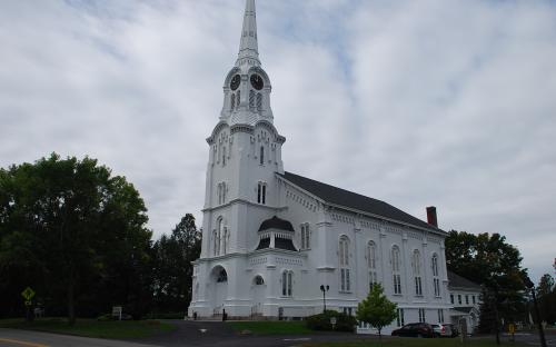
Architectural Description:
NRDIS NRMRA
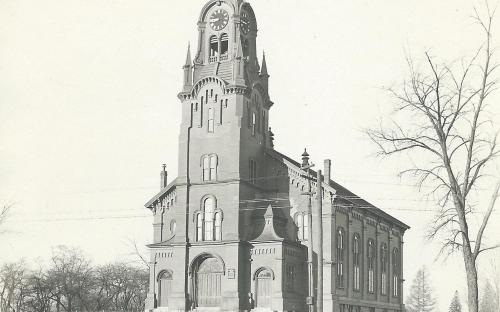
Style: Gothic Revival & Romanesque Revival
Other features:
South Burial Yard at rear, established in 1712 - oldest gravestone extant 1723;
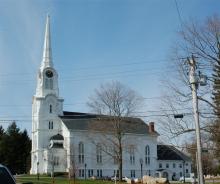
Only church in Andover with a clock tower
Historical Narrative:
Original and Present owner: South Church Inc.
Themes: Architectural, Community development, Religion
Historical significance: Nov. 2, 1708, Andover was divided into two parishes by order of General Court. Resident of the South End of town complained that the distance was too great to attend services at North Parish Meeting House and growth of town necessitated a second meeting house of worship.
First South Parish meeting house built 1710 - 1711, Samuel Phillips, minister. First building "at ye rock on west side of Roger's Brook" - [The rock here mentioned was near the site of the present Centre School House, and was removed in the year 1844.p. 27 Historical Manual of South Church InAndover, Mass, 1859] The school house was located on the open lot to the north of the church near the playground.
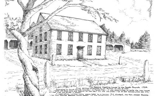
The current church edifice is the forth church structure on this site built in 1861. The first structure (1710- May 12, 1734) was a simple meeting house similar to existing meeting houses in Danville, Atkinson and Freemont, NH. In 1734 the Parish voted to replaced the meeting house with a larger one and the first sermon was preached on May 19, 1734. The building was 44' wide x 56' long and 30' in height from plate to sill. It served the Parish from 1734 - to April 20,1788.
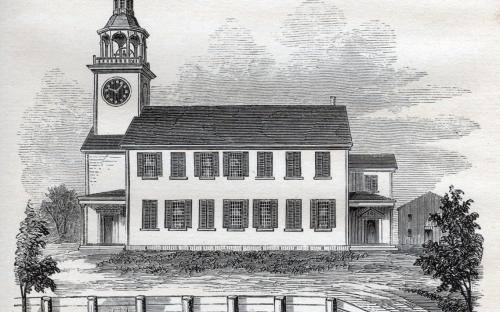
The third meetinghouse was larger still, needed to house the expanding congregation. There was however great discussion as to where to build the new meeting house as many parishioners were in favor of a site on the west side of the river. It was built next to the old one. "The dimensions were to be seventy feet in length and fifty-four in width", "with a porch at each end and one in the front of the house." The frame was raised on May 26 & 27,1788 and the first service held on Dec. 7, 1788. It remained in use until 1861 when replace with the present structure which at this date is 153 years.
The cupola or spire was built in the spring of 1792 and on June 11th Samuel Abbot, Esq. gave the church an 1100 pound bell for the tower. On March 5, 1812 Abbot also gave the clock for the tower. Samuel died the following month April 12, 1812 age 80 yrs.
In 1826 the South Parish was divided again for much the same reasons as the first division and all residents west of the Shawsheen River became charter members of the new West Parish Church and built their stone church that year.
In 1845 with the anti-slavery movement and abolitionist issues, some members of both the South and West Parish Churches left to create the new Free Christian Church.
Today South Church is a thriving congregation as an "open & welcoming religious institution"
Bibliography/References:
May 3, 1995: Historic Preservation Certificate
May 2002? Preservation Award for South Cemetery restoration.
Historical Manual of South Church in Andover, Mass. 1859
See also South Church Andover MA website for church activities and online data base of South Burial Ground & Cemetery interment records.
Inventory Data:
| Street | Central St |
| Place | Andover Center |
| Historic District | Central Street NRH District |
| Historic Name | South Church |
| Present Use | church |
| Original Use | church |
| Construction Date | 1861 |
| Source | A.H.S. files: Andover Townsman |
| Architectural Style | Gothic Revival |
| Architect/Builder | architect: John Stevens of Boston; builder: Abbot & Clement of Andover |
| Foundation | stone |
| Wall/Trim | wood clapboards |
| Roof | asphalt |
| Outbuildings / Secondary Structures | annex (1956) |
| Major Alterations | rear addition after fire (1900 - 1913) improvements (1953) Carriage sheds razed 1990's New addition on south side 2000 Solar panels on south slope of roof added 2012 |
| Condition | excellent |
| Acreage | 7.17 acres; approx. frontage: Central Street - 352', School Street - 676' |
| Setting | residential |
| Map and parcel | 55-156 |
| MHC Number | ANV.110 |
| Recorded by | Stack/Mofford, James Batchelder |
| Organization | Andover Preservation Commission |
| Date entered | 1975-1977, 4/2014 |
